
فائل:Sint Maarten-CIA WFB Map.png
اس سے زیادہ ریزولیوشن دستیاب نہیں۔
Sint_Maarten-CIA_WFB_Map.png (330 × 353 پکسل، فائل کا حجم: 14 کلوبائٹ، MIME قسم: image/png)

|
This locator map image could be re-created using vector graphics as an SVG file. This has several advantages; see Commons:Media for cleanup for more information. If an SVG form of this image is available, please upload it and afterwards replace this template with
{{vector version available|new image name}}.
It is recommended to name the SVG file “Sint Maarten-CIA WFB Map.svg”—then the template Vector version available (or Vva) does not need the new image name parameter. |
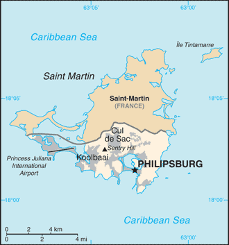
| تفصیل | Map of Sint Maarten from the 2010-10-22 revision of the World Factbook |
| تاریخ | |
| ماخذ | World Factbook website |
| مصنف | Directorate of Intelligence, CIA |
This image is in the public domain because it contains materials that originally came from the United States Central Intelligence Agency's World Factbook.
|
 |
فائل کا تاریخچہ
کسی خاص وقت یا تاریخ میں یہ فائل کیسی نظر آتی تھی، اسے دیکھنے کے لیے اس وقت/تاریخ پر کلک کریں۔
| تاریخ/وقت | تھمب نیل | ابعاد | صارف | تبصرہ | |
|---|---|---|---|---|---|
| رائج الوقت | 11:32، 23 اکتوبر 2010ء | | 330 × 353 (14 کلوبائٹ) | Hoshie | {{Information |Description= Map of {{w|Sint Maarten}} from the 2010-10-22 revision of the World Factbook |Source= [https://www.cia.gov/library/publications/the-world-factbook/maps/maptemplate_sk.html World Factbook website] |Date= 2010-10-22 |Author= Dire |
روابط
درج ذیل صفحہ اس فائل کو استعمال کر رہا ہے:
فائل کا عالمی استعمال
مندرجہ ذیل ویکیوں میں یہ فائل زیر استعمال ہے:
- af.wikipedia.org پر استعمال
- bn.wikipedia.org پر استعمال
- ceb.wikipedia.org پر استعمال
- el.wikipedia.org پر استعمال
- en.wikipedia.org پر استعمال
- fa.wikipedia.org پر استعمال
- fr.wikipedia.org پر استعمال
- gcr.wikipedia.org پر استعمال
- gom.wikipedia.org پر استعمال
- hi.wikipedia.org پر استعمال
- hu.wikipedia.org پر استعمال
- ia.wikipedia.org پر استعمال
- id.wikipedia.org پر استعمال
- incubator.wikimedia.org پر استعمال
- it.wikipedia.org پر استعمال
- ja.wikipedia.org پر استعمال
- lad.wikipedia.org پر استعمال
- lb.wikipedia.org پر استعمال
- mk.wikipedia.org پر استعمال
- ml.wikipedia.org پر استعمال
- nl.wikipedia.org پر استعمال
- pa.wikipedia.org پر استعمال
- pl.wikipedia.org پر استعمال
- ru.wikipedia.org پر استعمال
- sc.wikipedia.org پر استعمال
- shn.wikipedia.org پر استعمال
- simple.wikipedia.org پر استعمال
- su.wikipedia.org پر استعمال
- ta.wikipedia.org پر استعمال
- to.wikipedia.org پر استعمال
- tr.wikipedia.org پر استعمال
- tt.wikipedia.org پر استعمال
- uk.wikipedia.org پر استعمال
- vec.wikipedia.org پر استعمال
- www.wikidata.org پر استعمال
- zh-yue.wikipedia.org پر استعمال
- zh.wikipedia.org پر استعمال