
فائل:Australia cadastral subdivsions counties.png
اس سے زیادہ ریزولیوشن دستیاب نہیں۔
Australia_cadastral_subdivsions_counties.png (500 × 468 پکسل، فائل کا حجم: 39 کلوبائٹ، MIME قسم: image/png)
خلاصہ
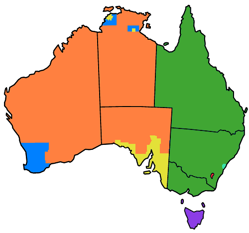
No counties, parishes or hundreds
Former counties, no further subdivisions
Counties, subdivided into hundreds
Counties, subdivided into parishes
Land Districts (formerly counties), subdivided into parishes, and formerly with hundreds. (Except King Island and Flinders Island, which were not part of counties, but are now land districts)
Formerly counties and parishes (ACT)
Counties, subdivided into parishes, and formerly with hundreds also (Cumberland)
Parts of Australia divided into counties for cadastral purposes, mostly this took place during the nineteenth century. (The line in South Australia is an approximation - this map shows counties in SA in 1886, but later others were added - not sure of exact location.) The ACT was once part of counties in NSW (Murray and Cowley) but no longer. Based on Golbez's GNU licenced map of Australia here
اجازہ کاری

|
آپ کو آزاد سافٹ ویئر فاؤنڈیشن کی جانب سے شائع کردہ جی این یو آزاد مسوداتی اجازت نامہ کی شرائط استعمال کے تحت اس دستاویز کو نقل، تقسیم اور/ یا ترمیم کرنے کی اجازت دی جاتی ہے۔ اس اجازت نامہ کی ایک نقل 'جی این یو آزاد مسوداتی اجازت نامہ کے عنوان سے میسر ہے۔ |
| اس ملف کا لائسنس Creative Commons Attribution-Share Alike 3.0 Unported کے تحط ہے۔ | ||
| ||
| This licensing tag was added to this file as part of the GFDL licensing update. |
فائل کا تاریخچہ
کسی خاص وقت یا تاریخ میں یہ فائل کیسی نظر آتی تھی، اسے دیکھنے کے لیے اس وقت/تاریخ پر کلک کریں۔
| تاریخ/وقت | تھمب نیل | ابعاد | صارف | تبصرہ | |
|---|---|---|---|---|---|
| رائج الوقت | 02:35، 2 مئی 2007ء | | 500 × 468 (39 کلوبائٹ) | Roke~commonswiki | tasmanian counties renamed land districts |
| 09:38، 18 اپریل 2007ء |  | 500 × 468 (39 کلوبائٹ) | Roke~commonswiki | Reverted to earlier revision | |
| 10:18، 7 اپریل 2007ء |  | 500 × 468 (37 کلوبائٹ) | Roke~commonswiki | ||
| 10:03، 7 اپریل 2007ء |  | 500 × 468 (39 کلوبائٹ) | Roke~commonswiki | == Summary == {{legend|#ff8040|No counties, parishes or hundreds}} {{legend|#0080ff|Counties, but no further subdivisions}} {{legend|#e3e138|Hundreds}} {{legend|#40a633|Parishes}} {{legend|#f62840|Formerly parishes (ACT) |
روابط
درج ذیل صفحہ اس فائل کو استعمال کر رہا ہے:
فائل کا عالمی استعمال
مندرجہ ذیل ویکیوں میں یہ فائل زیر استعمال ہے:
- en.wikipedia.org پر استعمال
- fa.wikipedia.org پر استعمال
- id.wikipedia.org پر استعمال
- pt.wikipedia.org پر استعمال