
فائل:AustriaHungaryWWI.gif
اس نمائش کا حجم: 681 × 599 پکسلز۔ دیگر تصمیمات: 273 × 240 پکسلز | 545 × 480 پکسلز | 776 × 683 پکسلز۔
اصل فائل (776 × 683 پکسل، فائل کا حجم: 98 کلوبائٹ، MIME قسم: image/gif)
خلاصہ
| تفصیل |
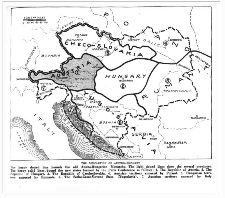
English: Drafted borders of Austria-Hungary in the Treaty of Trianon and Saint Germain. (map as published in the magazine; may differ from the later implementation of the treaty) |
| تاریخ | |
| ماخذ |
https://babel.hathitrust.org/cgi/pt?id=iau.31858029095456;view=1up;seq=427 (Jump to 391) The Independent (New York), June 14, vol. 98, 1919, p. 391 (Primary source, if any, not cited) |
| مصنف | The Independent |
اولین اپلوڈ کا نوشتہ
فائل کی تفصیلات کا اصل صفحہ یہاں تھا۔ درج ذیل تمام صارفین en.wikipedia کے ہیں۔
- 2009-01-20 00:44 Bizso 776×683 (100493 bytes)
اجازہ کاری
| اس ملف کا لائسنس Creative Commons Attribution-Share Alike 3.0 Unported کے تحط ہے۔ Subject to disclaimers. | ||
| ||
| This licensing tag was added to this file as part of the GFDL licensing update. |

|
آپ کو آزاد سافٹ ویئر فاؤنڈیشن کی جانب سے شائع کردہ جی این یو آزاد مسوداتی اجازت نامہ کی شرائط استعمال کے تحت اس دستاویز کو نقل، تقسیم اور/ یا ترمیم کرنے کی اجازت دی جاتی ہے۔ اس اجازت نامہ کی ایک نقل 'جی این یو آزاد مسوداتی اجازت نامہ کے عنوان سے میسر ہے۔ Subject to disclaimers. |
or
This media file is in the public domain in the United States. This applies to U.S. works where the copyright has expired, often because its first publication occurred prior to January 1, 1929, and if not then due to lack of notice or renewal. See this page for further explanation.
|
 | |
 |
This image might not be in the public domain outside of the United States; this especially applies in the countries and areas that do not apply the rule of the shorter term for US works, such as Canada, Mainland China (not Hong Kong or Macao), Germany, Mexico, and Switzerland. The creator and year of publication are essential information and must be provided. See Wikipedia:Public domain and Wikipedia:Copyrights for more details.
|
فائل کا تاریخچہ
کسی خاص وقت یا تاریخ میں یہ فائل کیسی نظر آتی تھی، اسے دیکھنے کے لیے اس وقت/تاریخ پر کلک کریں۔
| تاریخ/وقت | تھمب نیل | ابعاد | صارف | تبصرہ | |
|---|---|---|---|---|---|
| رائج الوقت | 05:39، 26 جنوری 2022ء | | 776 × 683 (98 کلوبائٹ) | GPinkerton | Reverted to version as of 22:53, 20 January 2009 (UTC) COM:CROP, manipulation of historical images |
| 11:11، 27 دسمبر 2021ء |  | 762 × 642 (97 کلوبائٹ) | Claude Zygiel | Sub-Carpathian Ruthenia never was Polish, this is not a "historical map" but an error of a newspaper: correcting it is not "manipulation". | |
| 04:31، 27 ستمبر 2021ء |  | 776 × 683 (98 کلوبائٹ) | GPinkerton | Reverted to version as of 22:53, 20 January 2009 (UTC) COM:CROP, manipulation of historical images | |
| 09:27، 23 جولائی 2020ء |  | 762 × 642 (97 کلوبائٹ) | Claude Zygiel | Better (see [https://commons.wikimedia.org/wiki/File:Dissolution_of_Austria-Hungary.png]) | |
| 22:53، 20 جنوری 2009ء |  | 776 × 683 (98 کلوبائٹ) | Bizso | {{Information |Description={{en|New hand-drawn borders of Austria-Hungary in the Treaty of Trianon and Saint Germain.}} |Source=Transferred from [http://en.wikipedia.org en.wikipedia]; transfer was stated to be made by User:Bizso.<br/> (Original text |
روابط
درج ذیل صفحہ اس فائل کو استعمال کر رہا ہے:
فائل کا عالمی استعمال
مندرجہ ذیل ویکیوں میں یہ فائل زیر استعمال ہے:
- azb.wikipedia.org پر استعمال
- bg.wikipedia.org پر استعمال
- ca.wikipedia.org پر استعمال
- cy.wikipedia.org پر استعمال
- el.wikipedia.org پر استعمال
- en.wikipedia.org پر استعمال
- ga.wikipedia.org پر استعمال
- gl.wikipedia.org پر استعمال
- he.wikipedia.org پر استعمال
- hr.wikipedia.org پر استعمال
- hy.wikipedia.org پر استعمال
- id.wikipedia.org پر استعمال
- it.wikipedia.org پر استعمال
- ko.wikipedia.org پر استعمال
- lv.wikipedia.org پر استعمال
- pnb.wikipedia.org پر استعمال
- pt.wikipedia.org پر استعمال
- ru.wikipedia.org پر استعمال
- sh.wikipedia.org پر استعمال
- simple.wikipedia.org پر استعمال
- sk.wikipedia.org پر استعمال
- th.wikipedia.org پر استعمال
- vi.wikipedia.org پر استعمال
- zh.wikipedia.org پر استعمال