
فائل:Blackfriars Station entrance geograph-3262754-by-Ben-Brooksbank.jpg

اس نمائش کا حجم: 800 × 495 پکسلز۔ دیگر تصمیمات: 320 × 198 پکسلز | 640 × 396 پکسلز | 1,024 × 633 پکسلز | 1,280 × 792 پکسلز | 2,343 × 1,449 پکسلز۔
اصل فائل (2,343 × 1,449 پکسل، فائل کا حجم: 2.72 MB، MIME قسم: image/jpeg)
خلاصہ
| تفصیل |
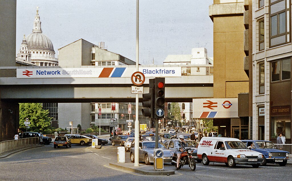
English: Outside Blackfriars Station, up Queen Victoria Street from New Bridge Street, 1989. View eastwards, with entrances on the right to the main (ex-SE&CR and Thameslink) and LT District and Circle Line) stations. The Thameslink service commenced in May 1988 and the bridge is now carrying Thameslink trains to/from Farringdon, King's Cross St Pancras, Luton and Bedford. (City Thameslink station was not yet built - it opened 29/5/90). St Paul's Cathedral is prominent on the left. |
| تاریخ | |
| ماخذ | From geograph.org.uk |
| مصنف | Ben Brooksbank |
| اجازت (فائل کا دوبارہ استعمال) |
Creative Commons Attribution Share-alike license 2.0 |
| لگاؤ (required by the license) | Ben Brooksbank / Outside Blackfriars Station, up Queen Victoria Street from New Bridge Street, 1989 / |
| Camera location | | View this and other nearby images on: OpenStreetMap |
|---|
اجازہ کاری

|
This image was taken from the Geograph project collection. See this photograph's page on the Geograph website for the photographer's contact details. The copyright on this image is owned by Ben Brooksbank and is licensed for reuse under the Creative Commons Attribution-ShareAlike 2.0 license.
|
This file is licensed under the Creative Commons Attribution-Share Alike 2.0 Generic license.
لگاؤ: Ben Brooksbank
- آپ آزاد ہیں:
- شیئر کرنے – کام کو نقل، تقسیم یا منتقل کرنے کے لیے
- ریمکس کے لیے – کام منبطق کرنے کے لیے
- مندرجہ ذیل شرائط کے تحت:
- انتساب – آپ کو اس کام کا انتساب مصنف یا اجازت دہندہ کے بتائے گئے طریقہ کے مطابق دینا ہوگا (تاہم یہ انتساب اس طرح نہیں ہونا چاہیے کہ اسے دیکھ کر ایسا محسوس ہو کہ اصل مصنف یا اجازت دہندہ آپ کے یا آپ کے ذریعہ اس کام کے استعمال کرنے کے حامی ہیں)۔
- یکساں شراکت – اگر آپ اس کام میں کوئی تبدیلی یا ترمیم کرتے ہیں یا اس کام پر مبنی کچھ نیا بناتے ہیں تو اسے بھی آپ اسی یا اس جیسے کسی اجازت نامے کے تحت شائع کر سکتے ہیں۔
فائل کا تاریخچہ
کسی خاص وقت یا تاریخ میں یہ فائل کیسی نظر آتی تھی، اسے دیکھنے کے لیے اس وقت/تاریخ پر کلک کریں۔
| تاریخ/وقت | تھمب نیل | ابعاد | صارف | تبصرہ | |
|---|---|---|---|---|---|
| رائج الوقت | 11:38، 27 دسمبر 2012ء | | 2,343 × 1,449 (2.72 MB) | Chevin | == {{int:filedesc}} == {{Information |Description={{en|1='''Outside Blackfriars Station, up Queen Victoria Street from New Bridge Street, 1989.'''<br/> View eastwards, with entrances on the right to the main (ex-SE&CR and Thameslink) and LT District an... |
روابط
درج ذیل صفحہ اس فائل کو استعمال کر رہا ہے:
فائل کا عالمی استعمال
مندرجہ ذیل ویکیوں میں یہ فائل زیر استعمال ہے:
- en.wikipedia.org پر استعمال
- zh.wikipedia.org پر استعمال