
فائل:Cape of Good Hope Iss059e078303 lrg.jpg
اس نمائش کا حجم: 800 × 533 پکسلز۔ دیگر تصمیمات: 320 × 213 پکسلز | 640 × 427 پکسلز | 1,024 × 683 پکسلز | 1,280 × 853 پکسلز | 2,560 × 1,707 پکسلز | 5,568 × 3,712 پکسلز۔
اصل فائل (5,568 × 3,712 پکسل، فائل کا حجم: 4.14 MB، MIME قسم: image/jpeg)
خلاصہ
| تفصیل |
Afrikaans: Uitsig oor Kaapstad, die Kaapse Skiereiland en Kaapse Vlakte vanuit die Internasionale Ruimtestasie. Ruimtevaarderfoto ISS059-E-78303 is op 28 Mei 2019 verkry deur middel van 'n Nikon D5 digitale kamera met 340 millimeter lens, en is voorsien deur die IRS-bemanning se Aardwaarnemingsgerief en die Aardwetenskap-en-Afstandwaarnemingseenheid van die Johnson-ruimtesentrum. Die foto is geneem deur 'n lid van die Ekspedisie 59-span. Die beeld is geknip, die kontras is verbeter en lens-artefakte is verwyder.
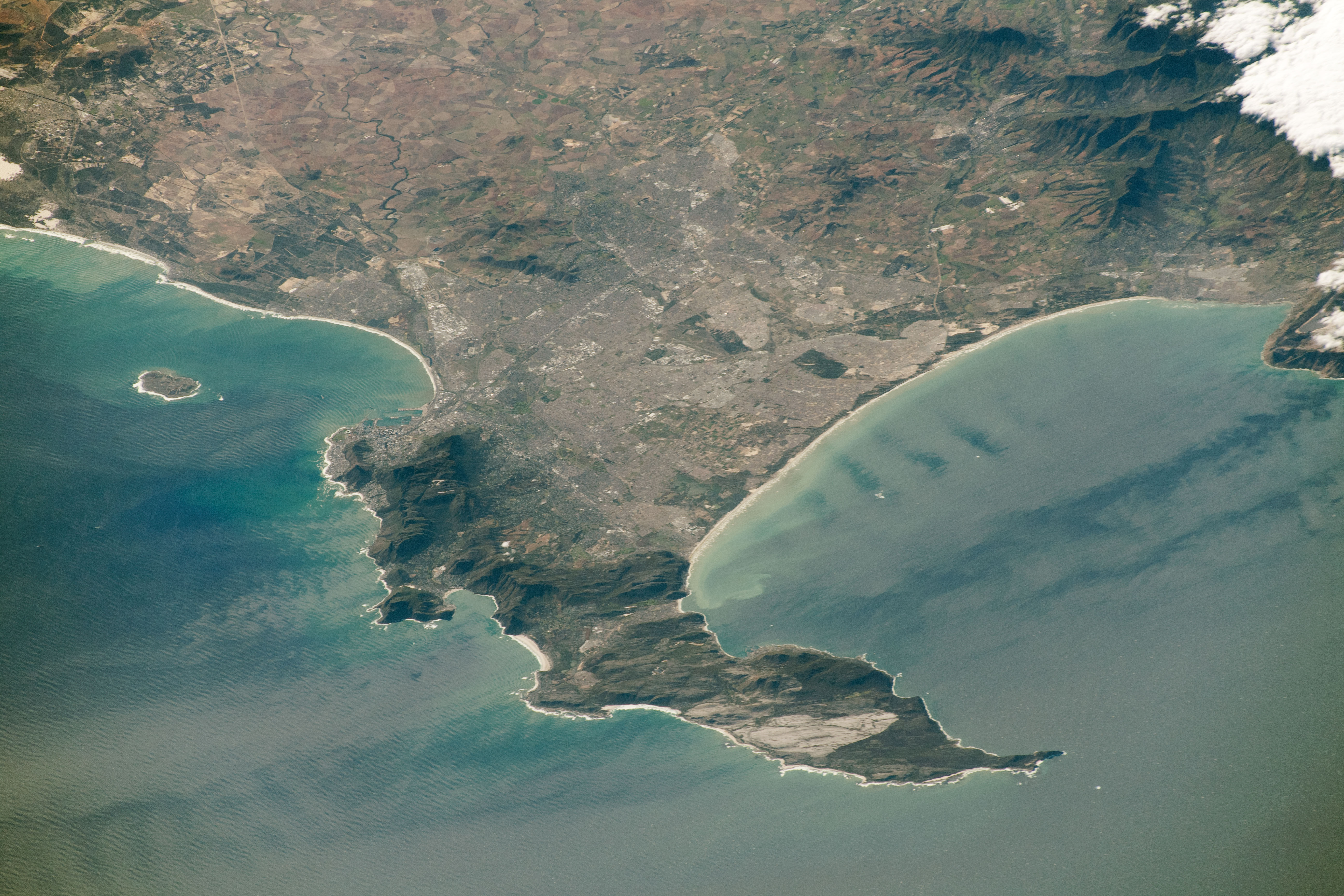
English: View of City of Cape Town showing the Cape Peninsula and Cape Flats from the International Space Station. Astronaut photograph ISS059-E-78303 was acquired on May 28, 2019, with a Nikon D5 digital camera using a 340 millimeter lens and is provided by the ISS Crew Earth Observations Facility and the Earth Science and Remote Sensing Unit, Johnson Space Center. The image was taken by a member of the Expedition 59 crew. The image has been cropped and enhanced to improve contrast, and lens artifacts have been removed. |
| تاریخ | |
| ماخذ | https://eoimages.gsfc.nasa.gov/images/imagerecords/145000/145476/iss059e078303_lrg.jpg |
| مصنف |
Afrikaans: Die Internasionale Ruimtestasieprogram ondersteun die laboratorium as deel van die IRS Nasionale Laboratorium om ruimtevaarders te help om foto's van die Aarde te neem wat die grootste waarde vir wetenskaplikes en die publiek sal hê, en om hierdie beelde vrylik op die internet beskikbaar te stel. Bykomende beelde wat deur ruimtevaarders en kosmonoute geneem is, kan besigtig word by die NASA/JSC Gateway to Astronaut Photography of Earth. Onderskrif deur Sarah Deitrick, 'n Jacobs-JETS-gekontrakteerde by NASA-JSC.
English: The International Space Station Program supports the laboratory as part of the ISS National Lab to help astronauts take pictures of Earth that will be of the greatest value to scientists and the public, and to make those images freely available on the Internet. Additional images taken by astronauts and cosmonauts can be viewed at the NASA/JSC Gateway to Astronaut Photography of Earth. Caption by Sarah Deitrick, Jacobs-JETS Contract at NASA-JSC. |
| دوسرے نسخے |
  |
| Object location | | View this and other nearby images on: OpenStreetMap |
|---|
اجازہ کاری
| This file is in the public domain in the United States because it was solely created by NASA. NASA copyright policy states that "NASA material is not protected by copyright unless noted". (See Template:PD-USGov, NASA copyright policy page or JPL Image Use Policy.) | ||
 |
Warnings:
|
فائل کا تاریخچہ
کسی خاص وقت یا تاریخ میں یہ فائل کیسی نظر آتی تھی، اسے دیکھنے کے لیے اس وقت/تاریخ پر کلک کریں۔
| تاریخ/وقت | تھمب نیل | ابعاد | صارف | تبصرہ | |
|---|---|---|---|---|---|
| رائج الوقت | 09:21، 28 اگست 2019ء | | 5,568 × 3,712 (4.14 MB) | Pbsouthwood | User created page with UploadWizard |
روابط
درج ذیل صفحہ اس فائل کو استعمال کر رہا ہے:
فائل کا عالمی استعمال
مندرجہ ذیل ویکیوں میں یہ فائل زیر استعمال ہے:
- en.wikipedia.org پر استعمال
- en.wiktionary.org پر استعمال
- fi.wikipedia.org پر استعمال
- pt.wikipedia.org پر استعمال