
فائل:Comanche County Oklahoma Incorporated areas highlighting Lawton.svg

اس SVG فائل کی PNG نمائش کا حجم: 582 × 599 پکسلز دیگر تصمیمات: 233 × 240 پکسلز | 466 × 480 پکسلز | 746 × 768 پکسلز | 995 × 1,024 پکسلز | 1,990 × 2,048 پکسلز۔
اصل فائل (ایس وی جی فائل، ابعاد 582 × 599 پکسل، فائل کا حجم: 801 کلوبائٹ)
خلاصہ
| تفصیل |
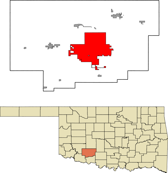
English: A map highlighting the city of Lawton in Comanche County in the US state of Oklahoma. Data provided from geo.ou.edu Based on similar maps from Ixnayonthetimmay |
| تاریخ | |
| ماخذ | ذاتی کام |
| مصنف | Crimsonedge34 |
| SVG genesis |
اجازہ کاری
میں اس تخلیقی کام کے حقوق کا مالک ہوں اور اسے مندرجہ ذیل اجازت نامے کے تحت شائع کرتا ہوں:
| This file is made available under the Creative Commons CC0 1.0 Universal Public Domain Dedication. | |
| The person who associated a work with this deed has dedicated the work to the public domain by waiving all of their rights to the work worldwide under copyright law, including all related and neighboring rights, to the extent allowed by law. You can copy, modify, distribute and perform the work, even for commercial purposes, all without asking permission.
|
فائل کا تاریخچہ
کسی خاص وقت یا تاریخ میں یہ فائل کیسی نظر آتی تھی، اسے دیکھنے کے لیے اس وقت/تاریخ پر کلک کریں۔
| تاریخ/وقت | تھمب نیل | ابعاد | صارف | تبصرہ | |
|---|---|---|---|---|---|
| رائج الوقت | 07:47، 13 اکتوبر 2011ء | | 582 × 599 (801 کلوبائٹ) | Crimsonedge34 | Margins |
| 06:49، 13 اکتوبر 2011ء |  | 692 × 646 (727 کلوبائٹ) | Crimsonedge34 | Would help if I uploaded the correct map. | |
| 06:48، 13 اکتوبر 2011ء |  | 1,052 × 744 (42 کلوبائٹ) | Crimsonedge34 | {{Information |Description ={{en|1=A map highlighting the city of Lawton in Comanche County in the US state of Oklahoma. Based on similar maps from Ixnayonthetimmay}} |Source ={{own}} |Author =[[User:Crimso |
روابط
درج ذیل صفحہ اس فائل کو استعمال کر رہا ہے:
فائل کا عالمی استعمال
مندرجہ ذیل ویکیوں میں یہ فائل زیر استعمال ہے:
- ar.wikipedia.org پر استعمال
- arz.wikipedia.org پر استعمال
- azb.wikipedia.org پر استعمال
- br.wikipedia.org پر استعمال
- ca.wikipedia.org پر استعمال
- en.wikipedia.org پر استعمال
- eu.wikipedia.org پر استعمال
- fa.wikipedia.org پر استعمال
- fi.wikipedia.org پر استعمال
- fr.wikipedia.org پر استعمال
- ga.wikipedia.org پر استعمال
- gd.wikipedia.org پر استعمال
- ht.wikipedia.org پر استعمال
- hu.wikipedia.org پر استعمال
- ia.wikipedia.org پر استعمال
- id.wikipedia.org پر استعمال
- kw.wikipedia.org پر استعمال
- no.wikipedia.org پر استعمال
- pt.wikipedia.org پر استعمال
- sh.wikipedia.org پر استعمال
- simple.wikipedia.org پر استعمال
- sr.wikipedia.org پر استعمال
- sv.wikipedia.org پر استعمال
- tr.wikipedia.org پر استعمال
- tt.wikipedia.org پر استعمال
- vo.wikipedia.org پر استعمال
- www.wikidata.org پر استعمال
- zh.wikipedia.org پر استعمال