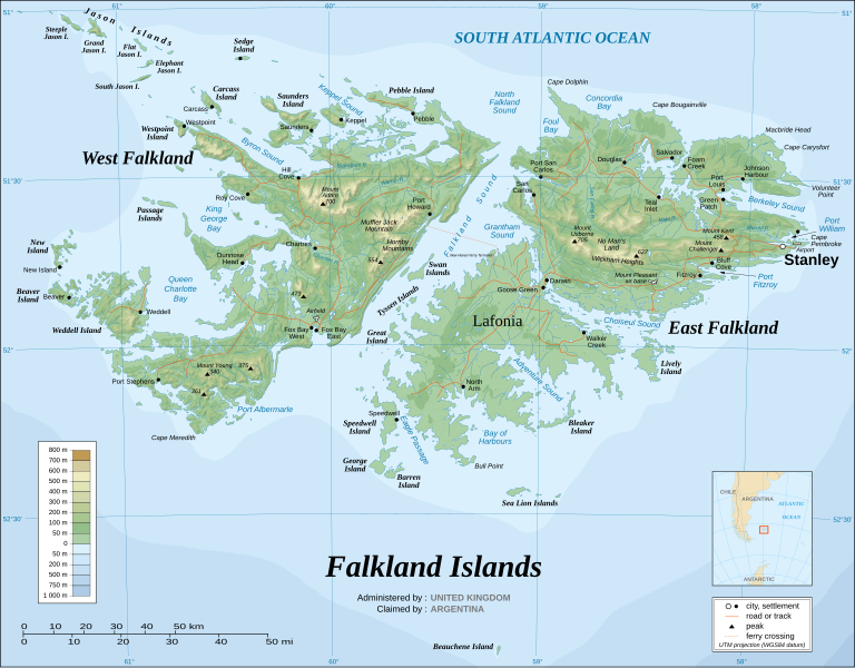
فائل:Falkland Islands topographic map-en.svg
صفحے کے مندرجات دوسری زبانوں میں قابل قبول نہیں ہیں۔
آزاد دائرۃ المعارف، ویکیپیڈیا سے

اصل فائل(ایس وی جی فائل، ابعاد 2,550 × 1,990 پکسل، فائل کا حجم: 1.97 MB)

یہ فائل ویکی ذخائر کی ہے اور دیگر منصوبوں کے زیر استعمال ہوسکتی ہے۔ فائل کے صفحہ تعارف پر موجود تعارف ذیل میں موجود ہے۔

 
  This SVG map uses required raster graphics to show delicate structures.
تصویر of the year
تصویر of the year
Featured تصویر

ویکی ذخائرویکیپیڈیا

This file was a candidate in Picture of the Year 2007.
This is a featured picture on Wikimedia Commons (Featured pictures) and is considered one of the finest images. See its nomination here.

 This is a featured picture on the English language Wikipedia (Featured pictures) and is considered one of the finest images. See its nomination here.

If you have an image of similar quality that can be published under a suitable copyright license, be sure to upload it, tag it, and nominate it.


Pour agrandir l'image

Detailed map of large dimension. For a better viewing, click on the link of the image above.
Carte détaillée de grande dimension. Pour une visualisation optimale, cliquer sur le lien de l'image ci-dessus.

خلاصہ

وضاحت
English: The Falkland Islands are an archipelago in the South Atlantic Ocean, located 300 miles off the coast of Argentina. They consist of two main islands, East Falkland and West Falkland, together with about 700 smaller islands. Stanley, on East Falkland, is the capital and largest city. The islands are a self-governing Overseas Territory of the United Kingdom.
Français : Carte topographique en anglais des Îles Malouines. Les Malouines forment un archipel dans l'Océan Atlantique Sud à 480 km des côtes argentines. Il est composé de deux îles principales, East Falkland et West Falkland, et de 700 autres îles et îlots. Stanley, sur East Falkland, est la capitale et la plus grande agglomération de l'archipel. Les Malouines sont un territoire autonome du Royaume-Uni.
Nederlands: Topografische kaart van de Falklandeilanden, een Brits overzees gebiedsdeel in de Zuidelijke Atlantische Oceaan. De archipel bestaat uit twee hoofdeilanden en ongeveer 700 kleinere op ongeveer 300 kilometer uit de kust van Argentinië. Stanley op het eiland 'East Falkland' is de hoofdstad en tergelijkertijd de meest bevolkte gemeente van het eilandengroep.De eilanden zijn een 'self-governing Overseas Territory' van het Verenigd Koninkrijk van Groot-Brittannië en Noord-Ierland.
Português: Mapa topográfico (em inglês) das Ilhas Malvinas, um arquipélago no sul do Oceano Atlântico, a 300 milhas da costa da Argentina. Consiste de duas ilhas, Soledad a leste e Gran Malvina, a oeste, junto com cerca de 700 outras ilhotas. A capital (e maior cidade) é Stanley. As Malvinas são um território autónomo do Reino Unido.
SVG genesis
InfoField
 
The SVG code is valid.
 
This map was created with Inkscape.
{| cellspacing="8" cellpadding="0" style="clear:both; width:100%; margin:0.5em auto; border:2px solid #88A; background-color:#F7F8FF;" lang="ur" dir="rtl"

|align="center"|اس فائل کا ترجمہ کریں

|width="100%"|

یہ ایس وی جی (SVG) فائل نصب شدہ متن (ایمبیڈڈ ٹیکسٹ) پر مشتمل ہے، جسے کسی بھی SVG ایڈیٹر یا ٹیکسٹ ایڈیٹر کا استعمال کرتے ہوئے یا SVG آلہ ترجمہ کی معاونت سے آپ کی زبان میں ترجمہ کیا جا سکتا ہے۔ مزید معلومات کے لیے دیکھیے: SVG فائلوں کا ترجمہ۔

|}
تاریخ November 2007 using elements from the original version of April 2007
ماخذ Own work ;
Topographic map : NASA Shuttle Radar Topography Mission (SRTM3 v.2) (public domain) edited with dlgv32 Pro/Global Mapper and vectorized with Inkscape ; UTM projection ; WGS84 datum ; shaded relief (composite image of N-W, W and N lightning positions) ;
Approximate scale of topographic data and shore / lakes limits : 1:705,000 ; of the bathymetry : 1:3.720.000
Bathymetry : USGov public domain data provided by the Demis add-on for World Wind (see the approval e-mail) ;
Other references used for additional data :
* UK government map ;
* NASA World Wind ;
* CIA map available on the site of the University of Texas at Austin ;
* Microsoft Encarta atlas (1999 edition).
Note : The shaded relief is a raster image embedded in the SVG file which increases its size. If you want a lighter map for other purposes, delete the shaded relief image in your file.
خالق
Eric Gaba (Sting - fr:Sting)
اجازت
(فائل کا دوبارہ استعمال)
Attribution and Share-Alike required
Georeferencing Georeference the map in Wikimaps Warper If inappropriate please set warp_status = skip to hide.
دوسرے نسخے

Derivative works of this file:

[ترمیم]


اجازہ کاری

میں اس کام کا کاپی رائٹ ہولڈر ہوں اور اسے مندرجہ ذیل اجازت ناموں کے تحت شائع کیا ہے:
GNU head آپ کو آزاد سافٹ ویئر فاؤنڈیشن کی جانب سے شائع کردہ جی این یو آزاد مسوداتی اجازت نامہ کی شرائط استعمال کے تحت اس دستاویز کو نقل، تقسیم اور/ یا ترمیم کرنے کی اجازت دی جاتی ہے۔ اس اجازت نامہ کی ایک نقل 'جی این یو آزاد مسوداتی اجازت نامہ کے عنوان سے میسر ہے۔
w:en:Creative Commons
انتساب یکساں شراکت
اس ملف کا لائسنس Creative Commons Attribution-Share Alike 3.0 Unported کے تحط ہے۔
آپ آزاد ہیں:
  • شیئر کرنے – کام کو نقل، تقسیم یا منتقل کرنے کے لیے
  • ریمکس کے لیے – کام منبطق کرنے کے لیے
مندرجہ ذیل شرائط کے تحت:
  • انتساب – آپ کو اس کام کا انتساب مصنف یا اجازت دہندہ کے بتائے گئے طریقہ کے مطابق دینا ہوگا (تاہم یہ انتساب اس طرح نہیں ہونا چاہیے کہ اسے دیکھ کر ایسا محسوس ہو کہ اصل مصنف یا اجازت دہندہ آپ کے یا آپ کے ذریعہ اس کام کے استعمال کرنے کے حامی ہیں)۔
  • یکساں شراکت – اگر آپ اس کام میں کوئی تبدیلی یا ترمیم کرتے ہیں یا اس کام پر مبنی کچھ نیا بناتے ہیں تو اسے بھی آپ اسی یا اس جیسے کسی اجازت نامے کے تحت شائع کر سکتے ہیں۔
This licensing tag was added to this file as part of the GFDL licensing update.
w:en:Creative Commons
انتساب یکساں شراکت
This file is licensed under the Creative Commons Attribution-Share Alike 2.5 Generic, 2.0 Generic and 1.0 Generic license.
آپ آزاد ہیں:
  • شیئر کرنے – کام کو نقل، تقسیم یا منتقل کرنے کے لیے
  • ریمکس کے لیے – کام منبطق کرنے کے لیے
مندرجہ ذیل شرائط کے تحت:
  • انتساب – آپ کو اس کام کا انتساب مصنف یا اجازت دہندہ کے بتائے گئے طریقہ کے مطابق دینا ہوگا (تاہم یہ انتساب اس طرح نہیں ہونا چاہیے کہ اسے دیکھ کر ایسا محسوس ہو کہ اصل مصنف یا اجازت دہندہ آپ کے یا آپ کے ذریعہ اس کام کے استعمال کرنے کے حامی ہیں)۔
  • یکساں شراکت – اگر آپ اس کام میں کوئی تبدیلی یا ترمیم کرتے ہیں یا اس کام پر مبنی کچھ نیا بناتے ہیں تو اسے بھی آپ اسی یا اس جیسے کسی اجازت نامے کے تحت شائع کر سکتے ہیں۔
آپ حسب منشا اجازت نامہ منتخب کر سکتے ہیں۔

Captions

Add a one-line explanation of what this file represents

Items portrayed in this file

عکاسی

topographic map انگریزی

media type انگریزی

image/svg+xml

فائل کا تاریخچہ

کسی خاص وقت یا تاریخ میں یہ فائل کیسی نظر آتی تھی، اسے دیکھنے کے لیے اس وقت/تاریخ پر کلک کریں۔

(تازہ ترین | قدیم ترین) (جدید 10 | ) دیکھیں (10 | 20 | 50 | 100 | 250 | 500)
تاریخ/وقتتھمب نیلابعادصارفتبصرہ
رائج الوقت02:51، 23 اگست 2021ءمورخہ 02:51، 23 اگست 2021ء کا تھمب نیل2,550 × 1,990 (1.97 MB)Praça de MaioFile uploaded using svgtranslate tool (https://svgtranslate.toolforge.org/). Added translation for tr.
02:50، 23 اگست 2021ءمورخہ 02:50، 23 اگست 2021ء کا تھمب نیل2,550 × 1,990 (1.97 MB)Praça de MaioFile uploaded using svgtranslate tool (https://svgtranslate.toolforge.org/). Added translation for tr.
11:54، 6 اپریل 2017ءمورخہ 11:54، 6 اپریل 2017ء کا تھمب نیل2,550 × 1,990 (1.91 MB)RaviC+ New Haven Ferry
18:38، 19 دسمبر 2008ءمورخہ 18:38، 19 دسمبر 2008ء کا تھمب نیل2,550 × 1,990 (1.93 MB)StingReverted to version as of 03:38, 14 November 2007: please upload the translated version under a specific name
18:26، 19 دسمبر 2008ءمورخہ 18:26، 19 دسمبر 2008ء کا تھمب نیل2,550 × 1,990 (1.93 MB)Vitekthis is just croatian translation
03:38، 14 نومبر 2007ءمورخہ 03:38، 14 نومبر 2007ء کا تھمب نیل2,550 × 1,990 (1.93 MB)StingNew version more accurate and with shaded relief
01:18، 16 جون 2007ءمورخہ 01:18، 16 جون 2007ء کا تھمب نیل2,550 × 1,990 (1.03 MB)StingReverted to earlier revision
01:03، 16 جون 2007ءمورخہ 01:03، 16 جون 2007ء کا تھمب نیل2,550 × 1,990 (2.14 MB)StingTrying to fix the bug on WP-en #8
00:40، 16 جون 2007ءمورخہ 00:40، 16 جون 2007ء کا تھمب نیل2,550 × 1,990 (2.01 MB)StingTrying to fix the bug on WP-en #7 (really boring...)
00:29، 16 جون 2007ءمورخہ 00:29، 16 جون 2007ء کا تھمب نیل2,550 × 1,990 (2.08 MB)StingTrying to fix the bug on WP-en #6 (OK, the problem comes from the shaded relief raster image)
(تازہ ترین | قدیم ترین) (جدید 10 | ) دیکھیں (10 | 20 | 50 | 100 | 250 | 500)

درج ذیل صفحہ اس فائل کو استعمال کر رہا ہے:

فائل کا عالمی استعمال

مندرجہ ذیل ویکیوں میں یہ فائل زیر استعمال ہے:

اس فائل کا مزید عالمی استعمال دیکھیے۔

میٹا ڈیٹا