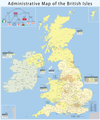
فائل:Map of the administrative geography of the United Kingdom.png

اس نمائش کا حجم: 402 × 599 پکسلز۔ دیگر تصمیمات: 161 × 240 پکسلز | 322 × 480 پکسلز | 516 × 768 پکسلز | 687 × 1,024 پکسلز | 1,375 × 2,048 پکسلز | 2,806 × 4,179 پکسلز۔
اصل فائل (2,806 × 4,179 پکسل، فائل کا حجم: 1.06 MB، MIME قسم: image/png)
فائل کا تاریخچہ
کسی خاص وقت یا تاریخ میں یہ فائل کیسی نظر آتی تھی، اسے دیکھنے کے لیے اس وقت/تاریخ پر کلک کریں۔
| تاریخ/وقت | تھمب نیل | ابعاد | صارف | تبصرہ | |
|---|---|---|---|---|---|
| رائج الوقت | 15:32، 1 اپریل 2023ء |  | 2,806 × 4,179 (1.06 MB) | NordNordWest | upd April 2023 |
| 21:34، 15 نومبر 2022ء |  | 2,806 × 4,179 (1.07 MB) | NordNordWest | update Buckinghamshire and Northamptonshire | |
| 18:38، 7 مئی 2019ء |  | 2,806 × 4,179 (1.77 MB) | Chumwa | Aktualisierung: Änderungen in der Verwaltungsgliederung am 1.4.2019 | |
| 18:10، 3 مارچ 2019ء |  | 2,806 × 4,179 (1.78 MB) | Chumwa | falsche Anzahl an non-metropolitan ceremonial counties im Infokasten für England korrigiert | |
| 19:21، 8 اکتوبر 2015ء |  | 2,806 × 4,179 (1.78 MB) | Chumwa | falsche Datei erwischt... | |
| 19:19، 8 اکتوبر 2015ء |  | 3,703 × 4,450 (2.29 MB) | Chumwa | Aktualisierung: Am 1. April ist eine Verwaltungsreform in Nordirland in Kraft getreten. | |
| 17:43، 15 اپریل 2013ء |  | 2,806 × 4,179 (1.82 MB) | Chumwa | Isle of Wight | |
| 21:50، 14 ستمبر 2011ء |  | 2,806 × 4,179 (1.68 MB) | Chumwa | corr | |
| 05:38، 27 مئی 2010ء |  | 2,806 × 4,179 (1.66 MB) | Chumwa | civil parishes were replaced by communities in Wales in 1974 | |
| 21:42، 25 مئی 2010ء |  | 2,806 × 4,179 (1.66 MB) | Chumwa | ein paar Verbesserungen... |
روابط
درج ذیل صفحہ اس فائل کو استعمال کر رہا ہے:
فائل کا عالمی استعمال
مندرجہ ذیل ویکیوں میں یہ فائل زیر استعمال ہے:
- ar.wikipedia.org پر استعمال
- az.wikipedia.org پر استعمال
- be.wikipedia.org پر استعمال
- bg.wikipedia.org پر استعمال
- bs.wikipedia.org پر استعمال
- de.wikipedia.org پر استعمال
- en.wikipedia.org پر استعمال
- Talk:Bromley and Chislehurst (UK Parliament constituency)
- Talk:Lewisham Deptford (UK Parliament constituency)
- Administrative geography of the United Kingdom
- Talk:University constituency
- Talk:Rotten and pocket boroughs
- Talk:Foyle (UK Parliament constituency)
- Talk:Fermanagh and South Tyrone (UK Parliament constituency)
- Talk:Belfast South (UK Parliament constituency)
- Talk:Belfast North (UK Parliament constituency)
- Talk:Combined Scottish Universities (UK Parliament constituency)
- Talk:Tralee (UK Parliament constituency)
- Talk:Belfast West (UK Parliament constituency)
- Category talk:Constituencies of the Parliament of the United Kingdom
- Talk:List of United Kingdom Parliament constituencies (2005–2010)
- Talk:Aberavon (UK Parliament constituency)
- Talk:Hampstead and Highgate (UK Parliament constituency)
- Talk:Folkestone and Hythe (UK Parliament constituency)
- Template:WikiProject UK Parliament constituencies
- Category talk:Constituencies of the Parliament of the United Kingdom (historic)
- Talk:Armagh (UK Parliament constituency)
- Talk:Caithness and Sutherland (UK Parliament constituency)
- Talk:East Gloucestershire (UK Parliament constituency)
- Talk:Londonderry (UK Parliament constituency)
- Talk:Queen's University of Belfast (UK Parliament constituency)
- Talk:Roscommon (constituency)
- Talk:Beckenham (UK Parliament constituency)
- Talk:Bosworth (UK Parliament constituency)
- Talk:Blaydon (UK Parliament constituency)
- Talk:Braintree (UK Parliament constituency)
- Talk:Bethnal Green and Bow (UK Parliament constituency)
- Talk:Bridgwater (UK Parliament constituency)
- Talk:Brent East (UK Parliament constituency)
- Talk:Bromsgrove (UK Parliament constituency)
- Talk:Caithness, Sutherland and Easter Ross (UK Parliament constituency)
- Talk:Calder Valley (UK Parliament constituency)
- Talk:North West Cambridgeshire (UK Parliament constituency)
- Talk:Canterbury (UK Parliament constituency)
اس فائل کا مزید عالمی استعمال دیکھیے۔


