
فائل:Map of the partition of the Kingdom of Poland and the Grand Duchy of Lithuania from 1799.jpg

اس نمائش کا حجم: 669 × 600 پکسلز۔ دیگر تصمیمات: 268 × 240 پکسلز | 535 × 480 پکسلز | 856 × 768 پکسلز | 1,142 × 1,024 پکسلز | 2,284 × 2,048 پکسلز | 6,330 × 5,677 پکسلز۔
اصل فائل (6,330 × 5,677 پکسل، فائل کا حجم: 6.83 MB، MIME قسم: image/jpeg)
خلاصہ
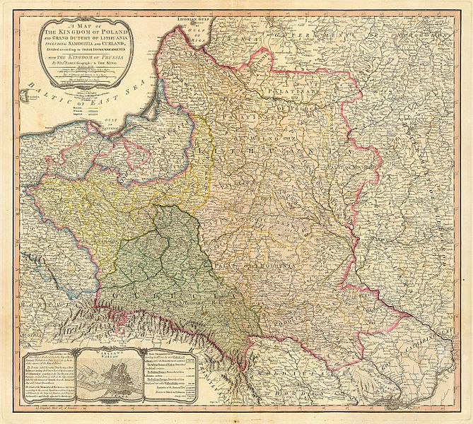
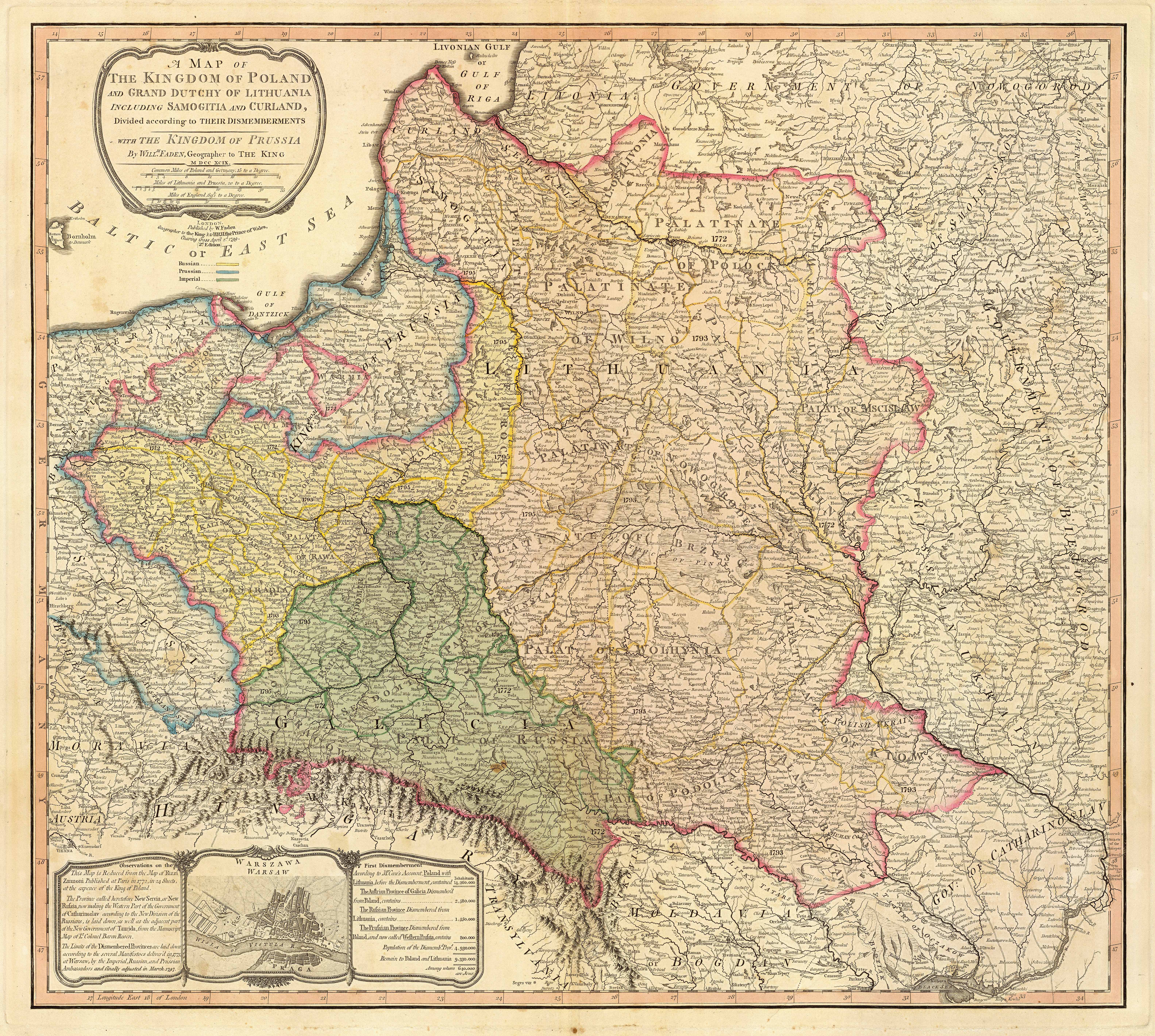
| تفصیل | Title: "A map of the Kingdom of Poland and the Grand Duchy of Lithuania including Samogitia and Curland divided according to their dismemberments with the Kingdom of Prussia". A map from 1799 showing how the Polish-Lithuanian Commonwealth was partitioned in 1765-1795 between Prussia, Austria, and Russia. This is an extremely detailed map which lists all the cities and small towns and labels the regions according to their English names. The boundaries former Polish-Lithuanian Commonwealth colored light red. The areas taken by Prussia are colored yellow, those taken by Austria colored green, and those taken by Russia are colored beige. Prussia itself is bordered in blue. Eastern Pomerania and Warmia are shown as part of Prussia but bordered in red as well. | ||||||||||||||||||||||
| تاریخ | |||||||||||||||||||||||
| ماخذ | http://www.belarusguide.com/images/maps/Kokosha/POlonia&Lituania-1799.jpg | ||||||||||||||||||||||
| مصنف |
|
||||||||||||||||||||||
اجازہ کاری
|
This work is in the public domain in its country of origin and other countries and areas where the copyright term is the author's life plus 100 years or fewer. | |
| This file has been identified as being free of known restrictions under copyright law, including all related and neighboring rights. | |
فائل کا تاریخچہ
کسی خاص وقت یا تاریخ میں یہ فائل کیسی نظر آتی تھی، اسے دیکھنے کے لیے اس وقت/تاریخ پر کلک کریں۔
| تاریخ/وقت | تھمب نیل | ابعاد | صارف | تبصرہ | |
|---|---|---|---|---|---|
| رائج الوقت | 05:04، 23 ستمبر 2007ء | | 6,330 × 5,677 (6.83 MB) | Archaeogenetics | {{Information |Description=Title: "A map of the Kingdom of Poland and the Grand Duchy of Lithuania including Samogitia and Curland divided according to their dismemberments with the Kingdom of Prussia". A map from 1799 showing how the Polish-Lithuanian Co |
روابط
درج ذیل صفحہ اس فائل کو استعمال کر رہا ہے:
فائل کا عالمی استعمال
مندرجہ ذیل ویکیوں میں یہ فائل زیر استعمال ہے:
- en.wikipedia.org پر استعمال
- et.wikipedia.org پر استعمال
- lt.wikipedia.org پر استعمال
- lt.wikibooks.org پر استعمال
- pnb.wikipedia.org پر استعمال
- th.wikipedia.org پر استعمال
- uk.wikipedia.org پر استعمال
- zh.wikipedia.org پر استعمال