
فائل:Population density of Ireland map2002.svg

اس SVG فائل کی PNG نمائش کا حجم: 480 × 600 پکسلز دیگر تصمیمات: 192 × 240 پکسلز | 384 × 480 پکسلز | 614 × 768 پکسلز | 819 × 1,024 پکسلز | 1,638 × 2,048 پکسلز۔
اصل فائل (ایس وی جی فائل، ابعاد 800 × 1,000 پکسل، فائل کا حجم: 621 کلوبائٹ)
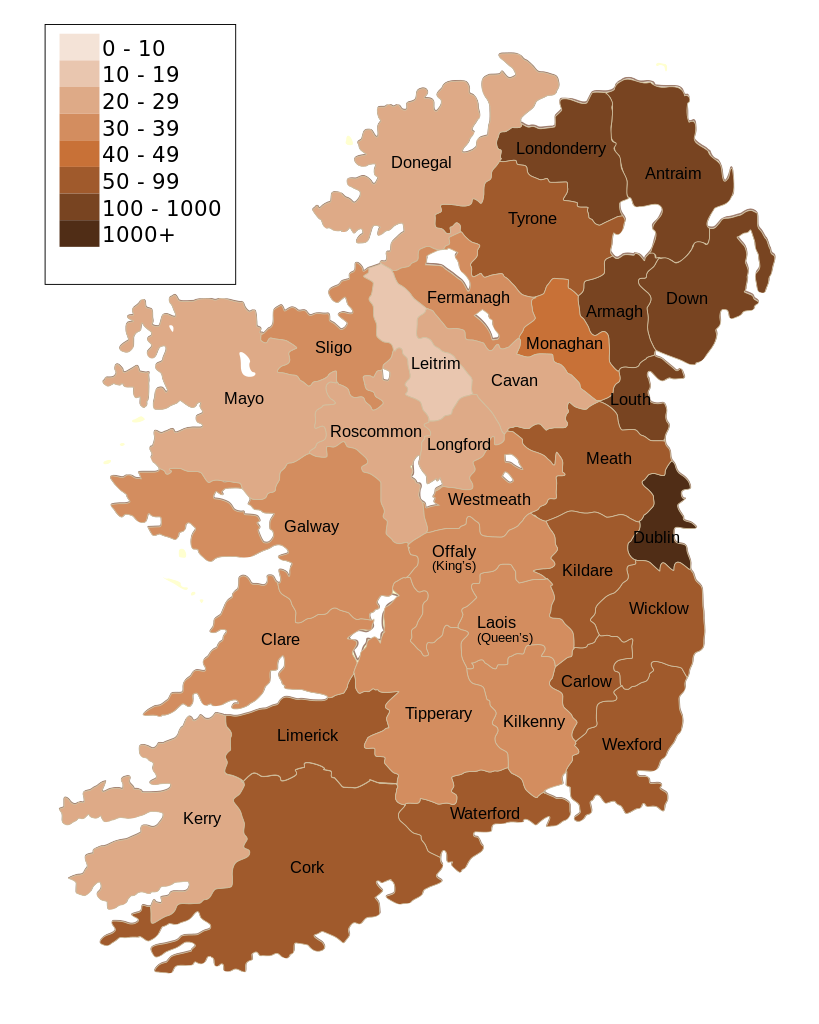
| تفصیل | Map of Ireland's population density (people per km2). Based upon Republic of Ireland - 2002 Census results. |
| تاریخ | (UTC) |
| ماخذ | |
| مصنف |
|
| دوسرے نسخے | Derivative works of this file: Population density of Ireland map2002 RU.svg |
| This is a retouched picture, which means that it has been digitally altered from its original version. Modifications: Map of Ireland's population density (people per km2). Based upon Republic of Ireland - 2002 Census results.. The original can be viewed here: Ireland complete.svg:
|
میں اس تخلیقی کام کے حقوق کا مالک ہوں اور اسے مندرجہ ذیل اجازت نامے کے تحت شائع کرتا ہوں:
| میں اس تخلیقی کام کے حقوق کا مالک ہوں اور اسے دائرہ عام میں شائع کرتا ہوں جس کا اطلاق عالمی سطح پر ہوتا ہے۔ بعض ملکوں میں یہ قانونی طور پر شاید ممکن نہ ہو؛ اگر ایسا ہے تو: میں ہر ایک کو کسی بھی مقصد کے لیے بغیر کسی شرط کے اس تصویر کے استعمال کا حق تفویض کرتا/کرتی ہوں، بجز اس صورت کے جس میں کوئی قانونی رکاوٹ موجود ہو۔ |
اولین اپلوڈ کا نوشتہ
This image is a derivative work of the following images:
- File:Ireland_complete.svg licensed with PD-self
- 2007-06-23T17:06:44Z Future Perfect at Sunrise 800x1000 (594536 Bytes) {{Information |Description= |Source=self-made |Date= |Author= [[User:Future Perfect at Sunrise|Future Perfect at Sunrise]] }}
- 2007-06-23T16:45:52Z Future Perfect at Sunrise 800x1000 (590003 Bytes) {{Information |Description= |Source=self-made |Date= |Author= [[User:Future Perfect at Sunrise|Future Perfect at Sunrise]] }}
- 2007-06-23T16:35:48Z Future Perfect at Sunrise 2000x2500 (606764 Bytes) {{Information |Description=SVG map of Ireland. |Source=self-made |Date=23 June 2007 |Author= [[User:Future Perfect at Sunrise|Future Perfect at Sunrise]] }} Note: the SVG code contains separate levels showing boundaries and
Uploaded with derivativeFX
فائل کا تاریخچہ
کسی خاص وقت یا تاریخ میں یہ فائل کیسی نظر آتی تھی، اسے دیکھنے کے لیے اس وقت/تاریخ پر کلک کریں۔
| تاریخ/وقت | تھمب نیل | ابعاد | صارف | تبصرہ | |
|---|---|---|---|---|---|
| رائج الوقت | 14:30، 17 اکتوبر 2009ء | | 800 × 1,000 (621 کلوبائٹ) | The Illusional Ministry | Dublin now in black text |
| 14:27، 17 اکتوبر 2009ء |  | 800 × 1,000 (621 کلوبائٹ) | The Illusional Ministry | {{Information |Description=Map of Ireland's population density (people per km2). Based upon Republic of Ireland - 2002 Census results. |Source=*File:Ireland_complete.svg |Date=2009-10-17 14:25 (UTC) |Author=*File:Ireland_complete.svg: '''Futur |
روابط
اس فائل سے مربوط کوئی صفحہ موجود نہیں ہے۔
فائل کا عالمی استعمال
مندرجہ ذیل ویکیوں میں یہ فائل زیر استعمال ہے:
- de.wikipedia.org پر استعمال
- gv.wikipedia.org پر استعمال
- he.wikipedia.org پر استعمال
- hu.wikipedia.org پر استعمال
- kn.wikipedia.org پر استعمال
- sd.wikipedia.org پر استعمال
- te.wikipedia.org پر استعمال