
فائل:Prince Edward Islands, EO-1 ALI satellite image, 5 May 2009.jpg
اصل فائل (5,000 × 5,000 پکسل، فائل کا حجم: 5.18 MB، MIME قسم: image/jpeg)
خلاصہ
| تفصیل |
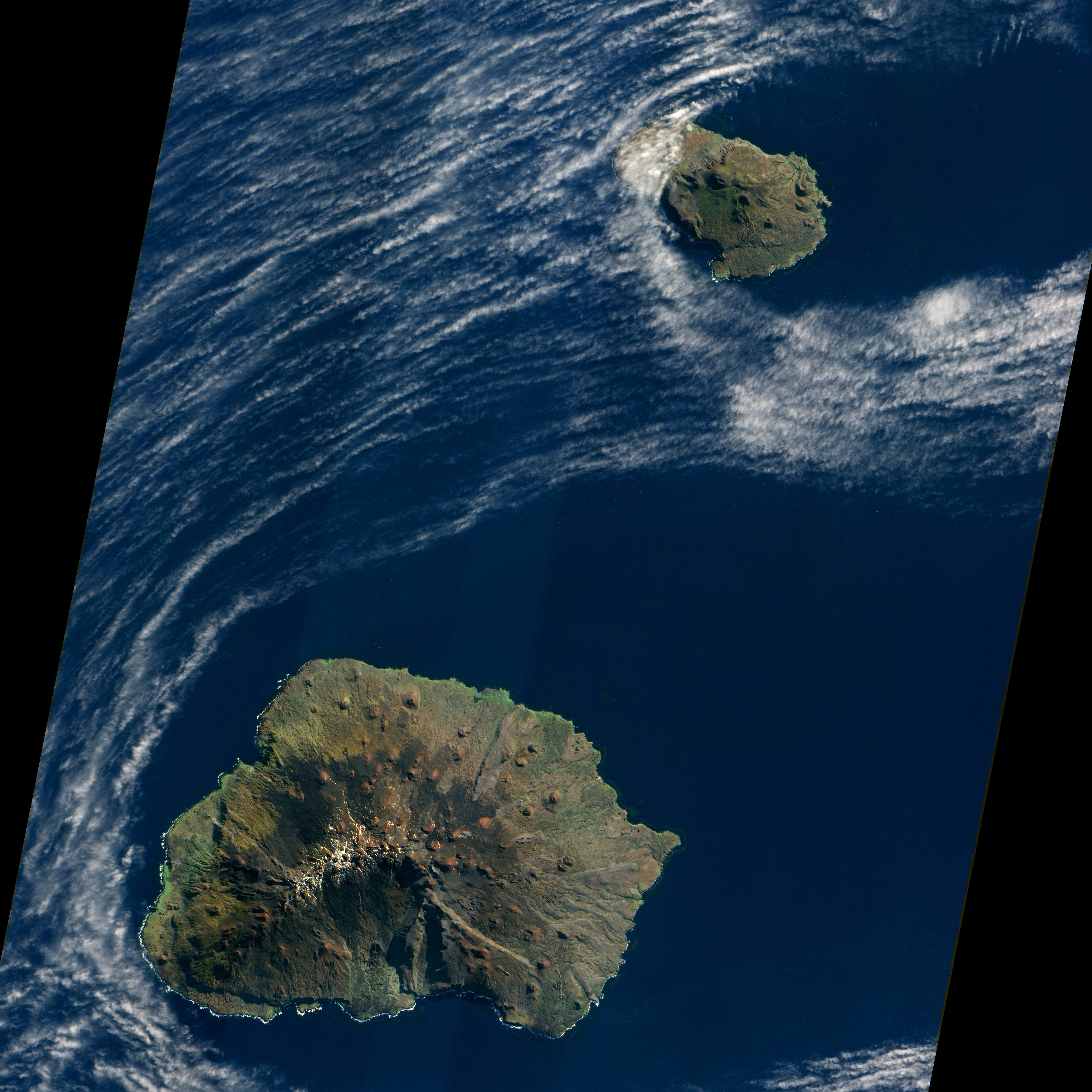
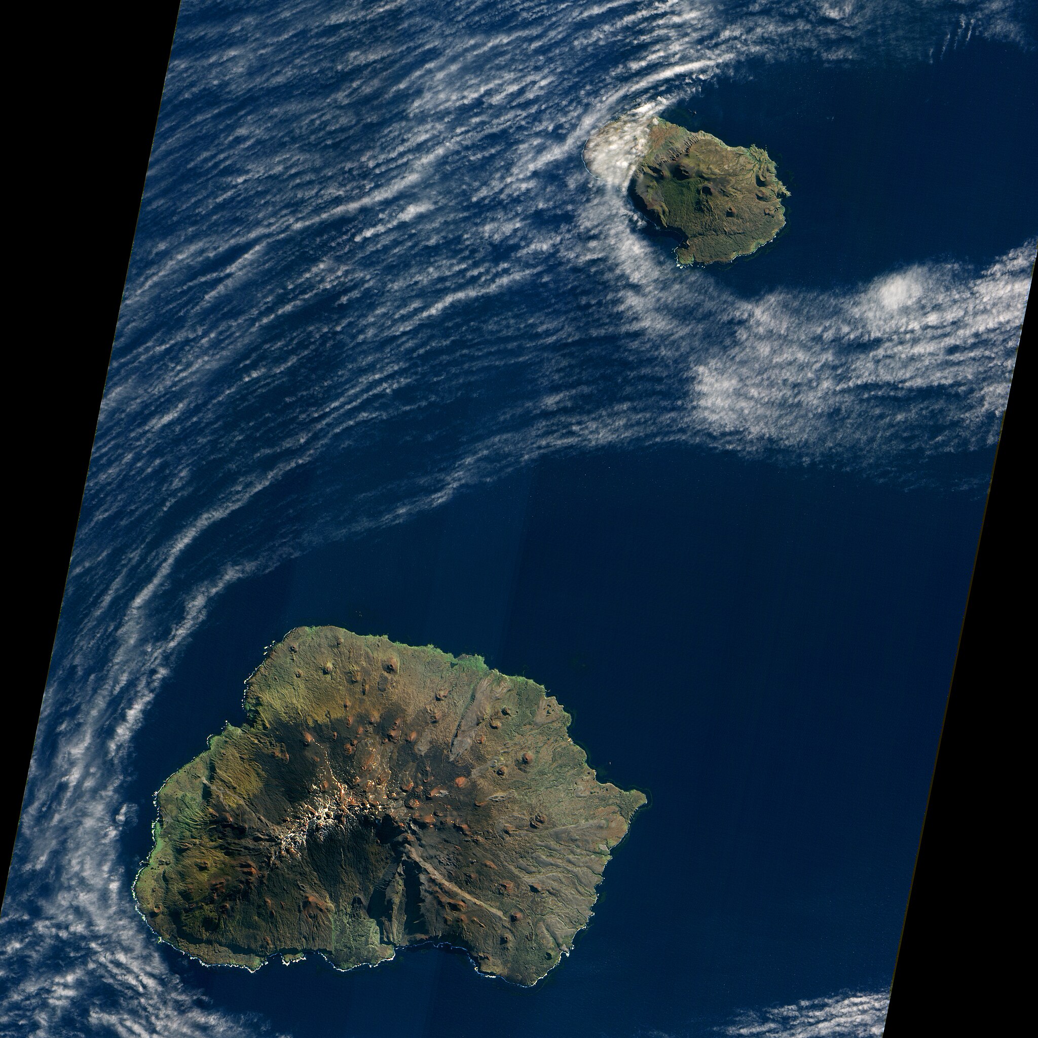
English: Satellite image of South Africa's Prince Edward Islands. Prince Edward Island is the smaller island near the top; Marion Island is the larger island below.
Original NASA caption, for a version cropped to show just Marion Island: "A dusting of ice graced the summit of Marion Island in early May 2009 as waves breaking against the island’s shore formed a broken perimeter of white. Like its smaller neighbor, Prince Edward Island, Marion Island is volcanic, rising above the waves of the Indian Ocean off the southern coast of Africa. Prince Edward and Marion are part of South Africa’s Western Cape Province. (Both islands appear in the large image.) "The Advanced Land Imager (ALI) on NASA’s Earth Observing-1 (EO-1) satellite acquired this natural-color image on May 5, 2009. Sunlight illuminates the northern slopes of the volcanic island, leaving southern slopes in shadow. More than 100 small, reddish volcanic cones dot the island, some of the most conspicuous in the north and east. The island reaches its highest elevation, 1,230 meters (4,040 feet), near the center. Vegetation is generally sparse on Marion Island. Lichens live near the summit, and mosses and ferns grow elsewhere on the boggy surface, but trees don’t grow on the island. "Occurring at the juncture between the African Continental Plate and the Antarctic Plate, Marion Island has been volcanically active for 18,000 years. The first historical eruption was recorded in November 1980 when researchers recorded two new volcanic hills and three lava flows. Researchers observed another small eruption in 2004. "Besides volcanic cones, Marion Island is home to Marion Base, part of the South African National Antarctic Programme. Focusing on biological, environmental, and meteorological research, the base is situated on the island’s northeastern coast." |
| تاریخ | |
| ماخذ | Image and description (of cropped version) |
| مصنف | NASA Earth Observatory image created by Jesse Allen, using EO-1 ALI data provided courtesy of the NASA EO-1 team and the United States Geological Survey. Caption by Michon Scott. |
| دوسرے نسخے |
|


| Camera location | | View this and other nearby images on: OpenStreetMap |
|---|
اجازہ کاری
| This file is in the public domain in the United States because it was solely created by NASA. NASA copyright policy states that "NASA material is not protected by copyright unless noted". (See Template:PD-USGov, NASA copyright policy page or JPL Image Use Policy.) | ||
 |
Warnings:
|
فائل کا تاریخچہ
کسی خاص وقت یا تاریخ میں یہ فائل کیسی نظر آتی تھی، اسے دیکھنے کے لیے اس وقت/تاریخ پر کلک کریں۔
| تاریخ/وقت | تھمب نیل | ابعاد | صارف | تبصرہ | |
|---|---|---|---|---|---|
| رائج الوقت | 21:19، 28 جنوری 2013ء | | 5,000 × 5,000 (5.18 MB) | Slick-o-bot | Bot: convert to a non-interlaced jpeg (see bug #17645) |
| 00:57، 5 اپریل 2011ء |  | 5,000 × 5,000 (5.08 MB) | Avenue | {{Information |Description ={{en|1=Satellite image of South Africa's Prince Edward Islands. Prince Edward Island is the smaller island near the top; Marion Island is the larger island below. Original NASA caption, for a version cropped to show just Ma |
روابط
درج ذیل صفحہ اس فائل کو استعمال کر رہا ہے:
فائل کا عالمی استعمال
مندرجہ ذیل ویکیوں میں یہ فائل زیر استعمال ہے:
- af.wikipedia.org پر استعمال
- ar.wikipedia.org پر استعمال
- ca.wikipedia.org پر استعمال
- ceb.wikipedia.org پر استعمال
- cs.wikipedia.org پر استعمال
- da.wikipedia.org پر استعمال
- de.wikipedia.org پر استعمال
- eo.wikipedia.org پر استعمال
- es.wikipedia.org پر استعمال
- eu.wikipedia.org پر استعمال
- fi.wikipedia.org پر استعمال
- fr.wikivoyage.org پر استعمال
- it.wikipedia.org پر استعمال
- nn.wikipedia.org پر استعمال
- no.wikipedia.org پر استعمال
- pl.wikipedia.org پر استعمال
- sv.wikipedia.org پر استعمال
- www.wikidata.org پر استعمال