فائل:Rødovre by night.jpg

صفحے کے مندرجات دوسری زبانوں میں قابل قبول نہیں ہیں۔
آزاد دائرۃ المعارف، ویکیپیڈیا سے

اصل فائل(4,287 × 2,222 پکسل، فائل کا حجم: 6 MB، MIME قسم: image/jpeg)

یہ فائل ویکی ذخائر کی ہے اور دیگر منصوبوں کے زیر استعمال ہوسکتی ہے۔ فائل کے صفحہ تعارف پر موجود تعارف ذیل میں موجود ہے۔

خلاصہ

تفصیل
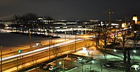
Dansk: Krydset Tårnvej/Rødovre Parkvej i Rødovre set fra Langhuset på en vinteraften. I venstre side ses den snedækkede græsplæne foran Rådhuset, i midten Rødovre Centrum og i højre side det illuminerede vandtårn.
Deutsch: Die Straßenkreuzung Tårnvej/Rødovre Parkvej in Rødovre gesehen von Langhuset aus an einem Winterabend. Links sieht man das schneebedeckte Grasstück vor dem Rathaus, im Mittel das Shopping Center Rødovre Centrum, und rechts den illuminierten Wasserturm.
English: The junction of Tårnvej and Rødovre Parkvej in Rødovre as seen from Langhuset on a winter evening. Left hand side: The snow-covered turf before the town hall. Middle section: The shopping mall Rødovre Centrum. Right hand side: The illuminated water tower.
تاریخ
ماخذ ذاتی کام
مصنف Bob Collowan
اجازت
(فائل کا دوبارہ استعمال)
This photo was taken by Bob Collowan

If possible, please credit this with: Bob Collowan/Commons/CC-BY-SA-4.0 in the immediate vicinity of the image.

If you use one of my photos outside Wikipedia and Commons, please email me (account needed) or leave me a short message on my discussion page. It would be greatly appreciated. Do not copy this image illegally by ignoring the terms of the license below, as it is not in the public domain. If you would like special permission to use, license, or purchase the image please contact me to negotiate terms.

Example:
© Bob Collowan, CC-BY-SA-4.0, Wikimedia Commons

This file has been released under a license which is incompatible with Facebook's licensing terms. It is not permitted to upload this file to Facebook.

Object location55° 40′ 50.2″ N, 12° 27′ 12.67″ E Kartographer map based on OpenStreetMap.View this and other nearby images on: OpenStreetMapinfo
Camera location55° 40′ 54.41″ N, 12° 27′ 06.63″ E Kartographer map based on OpenStreetMap.View this and other nearby images on: OpenStreetMapinfo

اجازہ کاری

میں اس تخلیقی کام کے حقوق کا مالک ہوں اور اسے مندرجہ ذیل اجازت نامے کے تحت شائع کرتا ہوں:
w:en:Creative Commons
انتساب یکساں شراکت
اس ملف کا لائسنس Creative Commons Attribution-Share Alike 3.0 Unported کے تحط ہے۔
آپ آزاد ہیں:
  • شیئر کرنے – کام کو نقل، تقسیم یا منتقل کرنے کے لیے
  • ریمکس کے لیے – کام منبطق کرنے کے لیے
مندرجہ ذیل شرائط کے تحت:
  • انتساب – آپ کو اس کام کا انتساب مصنف یا اجازت دہندہ کے بتائے گئے طریقہ کے مطابق دینا ہوگا (تاہم یہ انتساب اس طرح نہیں ہونا چاہیے کہ اسے دیکھ کر ایسا محسوس ہو کہ اصل مصنف یا اجازت دہندہ آپ کے یا آپ کے ذریعہ اس کام کے استعمال کرنے کے حامی ہیں)۔
  • یکساں شراکت – اگر آپ اس کام میں کوئی تبدیلی یا ترمیم کرتے ہیں یا اس کام پر مبنی کچھ نیا بناتے ہیں تو اسے بھی آپ اسی یا اس جیسے کسی اجازت نامے کے تحت شائع کر سکتے ہیں۔

VI seal

This image has been assessed under the valued image criteria and is considered the most valued image on Commons within the scope: Night photographs of Rødovre. You can see its nomination here.

This image has been assessed using the Quality image guidelines and is considered a Quality image.

العربية  جازايرية  беларуская  беларуская (тарашкевіца)  български  বাংলা  català  čeština  Cymraeg  Deutsch  Schweizer Hochdeutsch  Zazaki  Ελληνικά  English  Esperanto  español  eesti  euskara  فارسی  suomi  français  galego  עברית  हिन्दी  hrvatski  magyar  հայերեն  Bahasa Indonesia  italiano  日本語  Jawa  ქართული  한국어  kurdî  Lëtzebuergesch  lietuvių  македонски  മലയാളം  मराठी  Bahasa Melayu  Nederlands  Norfuk / Pitkern  polski  português  português do Brasil  rumantsch  română  русский  sicilianu  slovenčina  slovenščina  shqip  српски / srpski  svenska  தமிழ்  తెలుగు  ไทย  Tagalog  Türkçe  toki pona  українська  vèneto  Tiếng Việt  中文  中文(简体)  中文(繁體)  +/−

Captions

Add a one-line explanation of what this file represents

Items portrayed in this file

عکاسی

آغاز وقت: 5 جولائی 2013

23 جنوری 2013

source of file انگریزی

55°40'54.412"N, 12°27'6.631"E

55°40'50.20"N, 12°27'12.67"E

media type انگریزی

image/jpeg

فائل کا تاریخچہ

کسی خاص وقت یا تاریخ میں یہ فائل کیسی نظر آتی تھی، اسے دیکھنے کے لیے اس وقت/تاریخ پر کلک کریں۔

تاریخ/وقتتھمب نیلابعادصارفتبصرہ
رائج الوقت20:04، 6 جون 2013ءمورخہ 20:04، 6 جون 2013ء کا تھمب نیل4,287 × 2,222 (6 MB)Bob CollowânHigher resolution.
20:56، 23 جنوری 2013ءمورخہ 20:56، 23 جنوری 2013ء کا تھمب نیل2,144 × 1,111 (1.79 MB)Bob CollowânUser created page with UploadWizard

درج ذیل صفحہ اس فائل کو استعمال کر رہا ہے:

فائل کا عالمی استعمال

مندرجہ ذیل ویکیوں میں یہ فائل زیر استعمال ہے: