
فائل:Redwood City port aerial view.jpg

اس نمائش کا حجم: 800 × 533 پکسلز۔ دیگر تصمیمات: 320 × 213 پکسلز | 640 × 427 پکسلز | 1,024 × 683 پکسلز | 1,500 × 1,000 پکسلز۔
اصل فائل (1,500 × 1,000 پکسل، فائل کا حجم: 853 کلوبائٹ، MIME قسم: image/jpeg)
خلاصہ
| Camera location | | View this and other nearby images on: OpenStreetMap |
|---|
| تفصیل |
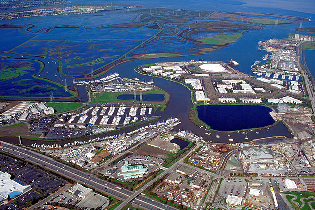
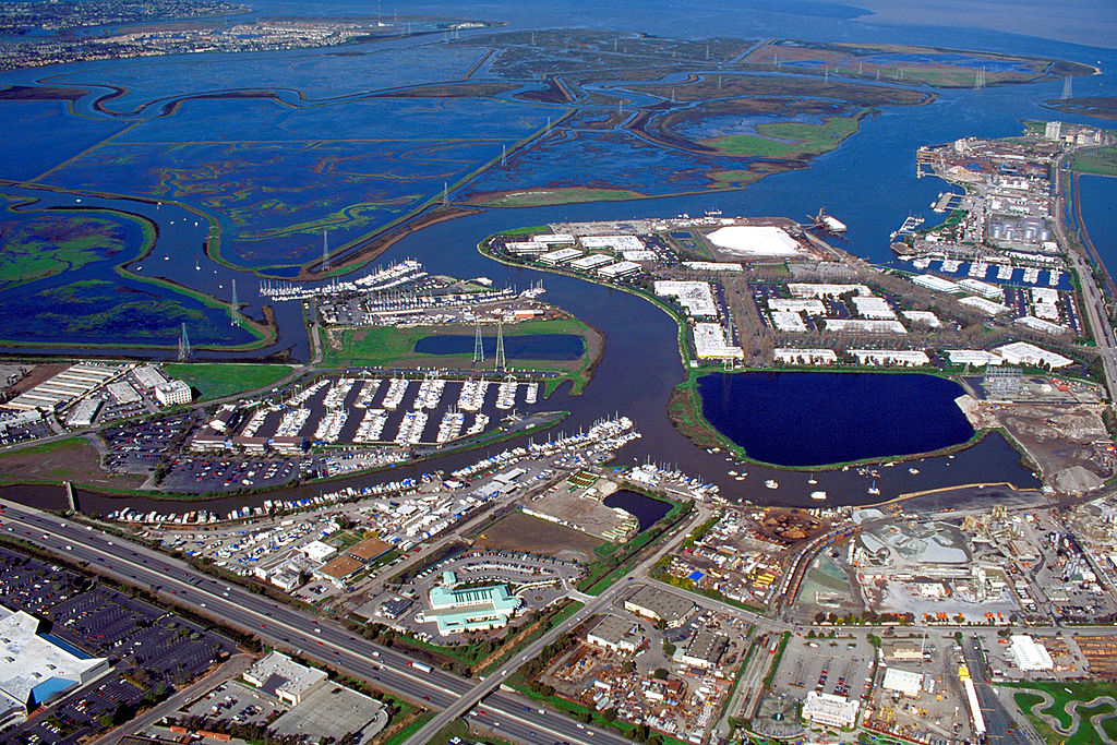
English: Aerial view of the port of Redwood City in San Mateo County, California, USA. The major deepwater port is visible at the far right in the photograph. Redwood Creek angles across the picture from lower left to upper right, forming the port and emptying into lower San Francisco Bay at the top. Corkscrew Slough winds across the wetlands of Bair Island at the top of the picture. View is to the northeast. |
|||
| تاریخ | not specified or unknown | |||
| ماخذ |
U.S. Army Corps of Engineers Digital Visual Library Image page Image description page Digital Visual Library home page |
|||
| مصنف | U.S. Army Corps of Engineers, photographer not specified or unknown | |||
| اجازت (فائل کا دوبارہ استعمال) |
|
فائل کا تاریخچہ
کسی خاص وقت یا تاریخ میں یہ فائل کیسی نظر آتی تھی، اسے دیکھنے کے لیے اس وقت/تاریخ پر کلک کریں۔
| تاریخ/وقت | تھمب نیل | ابعاد | صارف | تبصرہ | |
|---|---|---|---|---|---|
| رائج الوقت | 00:41، 5 مئی 2007ء | | 1,500 × 1,000 (853 کلوبائٹ) | DanMS | {{Information | Description = {{en|Aerial view of the port of Redwood City in San Mateo County, California, USA. The major deepwater port is visible at the far right in the photograph. Redwood Creek angles across the picture from lower left to upper ri |
روابط
درج ذیل صفحہ اس فائل کو استعمال کر رہا ہے:
فائل کا عالمی استعمال
مندرجہ ذیل ویکیوں میں یہ فائل زیر استعمال ہے:
- en.wikipedia.org پر استعمال
- Portal:San Francisco Bay Area/Selected picture/Archive
- Portal:San Francisco Bay Area/Did you know/Archive
- Port of Redwood City
- Redwood Creek (San Mateo County)
- Portal:California/Selected picture/4
- Portal:California/Selected picture/Archives
- Portal:San Francisco Bay Area/Selected picture/61
- User:Mercurywoodrose/SFBA galleries
- Portal:San Francisco Bay Area/Did you know/52
- es.wikipedia.org پر استعمال
- fi.wikipedia.org پر استعمال
- ja.wikipedia.org پر استعمال
- ml.wikipedia.org پر استعمال
- oc.wikipedia.org پر استعمال
- ru.wikipedia.org پر استعمال
- www.wikidata.org پر استعمال