
فائل:Richland-Plummer Creek Covered Bridge, southern side and eastern end.jpg

اس نمائش کا حجم: 800 × 600 پکسلز۔ دیگر تصمیمات: 320 × 240 پکسلز | 640 × 480 پکسلز | 1,024 × 768 پکسلز | 1,280 × 960 پکسلز | 2,560 × 1,920 پکسلز | 2,816 × 2,112 پکسلز۔
اصل فائل (2,816 × 2,112 پکسل، فائل کا حجم: 2.77 MB، MIME قسم: image/jpeg)
|
This is an image of a place or building that is listed on the National Register of Historic Places in the United States of America. Its reference number is 93000466. |
| Camera location | | View this and other nearby images on: OpenStreetMap |
|---|
| تفصیل |
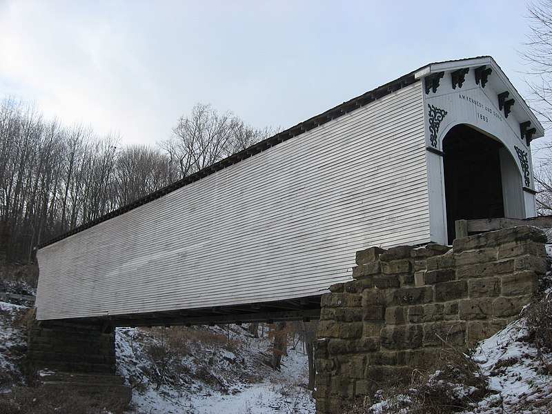
English: Southern side and eastern portal of the Richland-Plummer Creek Covered Bridge, which carries Baseline Road/Road 25E over Plummer Creek south of Bloomfield in Taylor Township, Greene County, Indiana, United States. Built in 1883, it is listed on the National Register of Historic Places. |
||
| تاریخ | Taken on 18 دسمبر 2010 | ||
| ماخذ | ذاتی کام | ||
| مصنف | Nyttend | ||
| اجازت (فائل کا دوبارہ استعمال) |
|
فائل کا تاریخچہ
کسی خاص وقت یا تاریخ میں یہ فائل کیسی نظر آتی تھی، اسے دیکھنے کے لیے اس وقت/تاریخ پر کلک کریں۔
| تاریخ/وقت | تھمب نیل | ابعاد | صارف | تبصرہ | |
|---|---|---|---|---|---|
| رائج الوقت | 13:01، 21 دسمبر 2010ء | | 2,816 × 2,112 (2.77 MB) | Nyttend | {{Location|38|59|34|N|86|56|16|W}} {{Information |Description={{en|Southern side and eastern portal of the {{w|Richland-Plummer Creek Covered Bridge}}, which carries Baseline Road/Road 25E over Plummer Creek south of {{w|Bloomfield, Indiana|Bloomfield}} i |
روابط
درج ذیل صفحہ اس فائل کو استعمال کر رہا ہے:
فائل کا عالمی استعمال
مندرجہ ذیل ویکیوں میں یہ فائل زیر استعمال ہے:
- en.wikipedia.org پر استعمال
- Bloomfield, Indiana
- Taylor Township, Greene County, Indiana
- List of bridges on the National Register of Historic Places in Indiana
- List of covered bridges in Indiana
- National Register of Historic Places listings in Greene County, Indiana
- Archibald M. Kennedy and sons
- List of Indiana state historical markers in Greene County
- Richland-Plummer Creek Covered Bridge
- es.wikipedia.org پر استعمال
- eu.wikipedia.org پر استعمال
- vi.wikipedia.org پر استعمال
- www.wikidata.org پر استعمال
- zh.wikipedia.org پر استعمال