
فائل:Satellite image of Hokkaido, Japan in May 2001.jpg

اس نمائش کا حجم: 450 × 600 پکسلز۔ دیگر تصمیمات: 180 × 240 پکسلز | 360 × 480 پکسلز | 576 × 768 پکسلز | 768 × 1,024 پکسلز | 2,400 × 3,200 پکسلز۔
اصل فائل (2,400 × 3,200 پکسل، فائل کا حجم: 466 کلوبائٹ، MIME قسم: image/jpeg)
خلاصہ
| تفصیل |
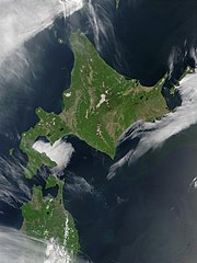
English: Satellite image of Hokkaido, Japan in May 2001. Taken from NASA's Visible Earth http://visibleearth.nasa.gov/view_rec.php?id=2060. This MODIS true-color image shows Hokkaido, Japan, at the top, and the northern tip of the island off Honshu at the bottom. Русский: Спутниковый снимок Хоккайдо (спутник Терра, NASA MODIS; май 2001 года) |
| تاریخ | |
| ماخذ | NASA |
| مصنف | NASA |
اجازہ کاری
| This file is in the public domain in the United States because it was solely created by NASA. NASA copyright policy states that "NASA material is not protected by copyright unless noted". (See Template:PD-USGov, NASA copyright policy page or JPL Image Use Policy.) | ||
 |
Warnings:
|
derivative works
Derivative works of this file: Akan volcano meakan-dake hokkaido japan space shot.jpg
| Annotations | This image is annotated: View the annotations at Commons |
فائل کا تاریخچہ
کسی خاص وقت یا تاریخ میں یہ فائل کیسی نظر آتی تھی، اسے دیکھنے کے لیے اس وقت/تاریخ پر کلک کریں۔
| تاریخ/وقت | تھمب نیل | ابعاد | صارف | تبصرہ | |
|---|---|---|---|---|---|
| رائج الوقت | 21:50، 7 مئی 2006ء | | 2,400 × 3,200 (466 کلوبائٹ) | Akanemoto~commonswiki | Satellite image of Hokkaido, Japan in May 2001. Taken from NASA's Visible Earth http://visibleearth.nasa.gov/view_rec.php?id=2060 |
روابط
درج ذیل صفحہ اس فائل کو استعمال کر رہا ہے:
فائل کا عالمی استعمال
مندرجہ ذیل ویکیوں میں یہ فائل زیر استعمال ہے:
- af.wikipedia.org پر استعمال
- ar.wikipedia.org پر استعمال
- arz.wikipedia.org پر استعمال
- ast.wikipedia.org پر استعمال
- bo.wikipedia.org پر استعمال
- ca.wikipedia.org پر استعمال
- en.wikipedia.org پر استعمال
- en.wiktionary.org پر استعمال
- eu.wikipedia.org پر استعمال
- fr.wikipedia.org پر استعمال
- ga.wikipedia.org پر استعمال
- gl.wikipedia.org پر استعمال
- ha.wikipedia.org پر استعمال
- hy.wikipedia.org پر استعمال
- id.wikipedia.org پر استعمال
- incubator.wikimedia.org پر استعمال
- it.wikipedia.org پر استعمال
- ja.wikipedia.org پر استعمال
- ja.wikibooks.org پر استعمال
- ko.wikipedia.org پر استعمال
- la.wikipedia.org پر استعمال
- ml.wikipedia.org پر استعمال
- nn.wikipedia.org پر استعمال
- oc.wikipedia.org پر استعمال
- pam.wikipedia.org پر استعمال
- pl.wikipedia.org پر استعمال
- pl.wiktionary.org پر استعمال
- pnb.wikipedia.org پر استعمال
- pt.wikipedia.org پر استعمال
- ru.wikipedia.org پر استعمال
- ru.wikinews.org پر استعمال
- sco.wikipedia.org پر استعمال
- simple.wikipedia.org پر استعمال
- sq.wikipedia.org پر استعمال
- sr.wikipedia.org پر استعمال
- sv.wikipedia.org پر استعمال
- szl.wikipedia.org پر استعمال
- ta.wikipedia.org پر استعمال
- tg.wikipedia.org پر استعمال
- uk.wikipedia.org پر استعمال
- vec.wikipedia.org پر استعمال
- vi.wikipedia.org پر استعمال
اس فائل کا مزید عالمی استعمال دیکھیے۔