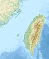
فائل:Taiwan relief location map.jpg

صفحے کے مندرجات دوسری زبانوں میں قابل قبول نہیں ہیں۔
آزاد دائرۃ المعارف، ویکیپیڈیا سے

اصل فائل(1,016 × 1,222 پکسل، فائل کا حجم: 101 کلوبائٹ، MIME قسم: image/jpeg)

یہ فائل ویکی ذخائر کی ہے اور دیگر منصوبوں کے زیر استعمال ہوسکتی ہے۔ فائل کے صفحہ تعارف پر موجود تعارف ذیل میں موجود ہے۔

Warning sign This file requires updating because: The earlier forms of this map did not extend a dotted-line around Dongyin, Lienchiang (Tungyin). The northern edge of this map ought to be moved up a little bit (in latitude) so that a dotted line encompassing Dongyin (Tungyin) can be clearly drawn and so that we can see a few of the islands north of Lienchiang County in Haidao Township, PRC. Example of a better map from The Economist: [1]. In doing so, you could add a timestamp to the file.
Please notify the uploader with {{subst:update-note|1=File:Taiwan relief location map.jpg|2=The earlier forms of this map did not extend a dotted-line around Dongyin, Lienchiang (Tungyin). The northern edge of this map ought to be moved up a little bit (in latitude) so that a dotted line encompassing Dongyin (Tungyin) can be clearly drawn and so that we can see a few of the islands north of Lienchiang County in Haidao Township, PRC. Example of a better map from The Economist: [2].}} ~~~~

خلاصہ

تفصیل
English: Relief location map of Taiwan.
  • Projection: Equirectangular projection, strechted by 110.0%.
  • Geographic limits of the map:
  • N: 26.4° N
  • S: 21.7° N
  • W: 118.0° E
  • E: 122.3° E
  • GMT projection: -JX17.204266666666665cd/20.68512992248063cd
  • GMT region: -R118.0/21.7/122.3/26.4r
  • GMT region for grdcut: -R118.0/21.7/122.3/26.4r
  • Relief: SRTM30plus.
  • Made with Natural Earth. Free vector and raster map data @ naturalearthdata.com.
تاریخ
ماخذ ذاتی کام
مصنف Uwe Dedering

اجازہ کاری

میں اس کام کا کاپی رائٹ ہولڈر ہوں اور اسے مندرجہ ذیل اجازت ناموں کے تحت شائع کیا ہے:
w:en:Creative Commons
انتساب یکساں شراکت
This file is licensed under the Creative Commons Attribution-Share Alike 3.0 Unported, 2.5 Generic, 2.0 Generic and 1.0 Generic license.
آپ آزاد ہیں:
  • شیئر کرنے – کام کو نقل، تقسیم یا منتقل کرنے کے لیے
  • ریمکس کے لیے – کام منبطق کرنے کے لیے
مندرجہ ذیل شرائط کے تحت:
  • انتساب – آپ کو اس کام کا انتساب مصنف یا اجازت دہندہ کے بتائے گئے طریقہ کے مطابق دینا ہوگا (تاہم یہ انتساب اس طرح نہیں ہونا چاہیے کہ اسے دیکھ کر ایسا محسوس ہو کہ اصل مصنف یا اجازت دہندہ آپ کے یا آپ کے ذریعہ اس کام کے استعمال کرنے کے حامی ہیں)۔
  • یکساں شراکت – اگر آپ اس کام میں کوئی تبدیلی یا ترمیم کرتے ہیں یا اس کام پر مبنی کچھ نیا بناتے ہیں تو اسے بھی آپ اسی یا اس جیسے کسی اجازت نامے کے تحت شائع کر سکتے ہیں۔
GNU head آپ کو آزاد سافٹ ویئر فاؤنڈیشن کی جانب سے شائع کردہ جی این یو آزاد مسوداتی اجازت نامہ کی شرائط استعمال کے تحت اس دستاویز کو نقل، تقسیم اور/ یا ترمیم کرنے کی اجازت دی جاتی ہے۔ اس اجازت نامہ کی ایک نقل 'جی این یو آزاد مسوداتی اجازت نامہ کے عنوان سے میسر ہے۔
آپ حسب منشا اجازت نامہ منتخب کر سکتے ہیں۔

Captions

Add a one-line explanation of what this file represents

Items portrayed in this file

عکاسی

source of file انگریزی

28 دسمبر 2010

MIME type انگریزی

image/jpeg

فائل کا تاریخچہ

کسی خاص وقت یا تاریخ میں یہ فائل کیسی نظر آتی تھی، اسے دیکھنے کے لیے اس وقت/تاریخ پر کلک کریں۔

تاریخ/وقتتھمب نیلابعادصارفتبصرہ
رائج الوقت14:01، 19 ستمبر 2019ءمورخہ 14:01، 19 ستمبر 2019ء کا تھمب نیل1,016 × 1,222 (101 کلوبائٹ)Geographyinitiativetemporary fix: extending the boundary out around Dongyin Township (as in China Fujian2 location map.svg and as in File:Nationalist China - administrative divisons. LOC 2007633622.jpg)
17:09، 3 اگست 2019ءمورخہ 17:09، 3 اگست 2019ء کا تھمب نیل1,016 × 1,222 (537 کلوبائٹ)NordNordWestborder corrections
01:51، 3 اگست 2019ءمورخہ 01:51، 3 اگست 2019ء کا تھمب نیل1,016 × 1,222 (96 کلوبائٹ)GeographyinitiativeProposed removal of three dashes (markers of the approximate PRC/ROC maritime boundary) which seemed to put Dadan Island, Erdan Island and Binlang Islet (檳榔嶼) outside the territory of Kinmen County, Taiwan/ROC. This is not the optimal form of the map, but is merely a quick removal of incorrect information. In the optimal situation, the line needs to be redrawn in the correct location, but I don't have the technical skill to produce such a map. (Basis: [http://ws.mac.gov.tw/001/Upload/OldFile/...
00:30، 3 اگست 2019ءمورخہ 00:30، 3 اگست 2019ء کا تھمب نیل1,016 × 1,222 (96 کلوبائٹ)GeographyinitiativeProposed removal of two dashes (markers of the approximate PRC/ROC maritime boundary) which seemed to put {{w|Dadan Island}} and {{w|Erdan Island}} outside the territory of {{w|Kinmen County}}, Taiwan/ROC.
17:22، 28 دسمبر 2010ءمورخہ 17:22، 28 دسمبر 2010ء کا تھمب نیل1,016 × 1,222 (452 کلوبائٹ)Uwe Dedering{{Information |Description={{en|1=Relief location map of Taiwan. * Projection: Equirectangular projection, strechted by 110.0%. * Geographic limits of the map: :* N: 26.4° N :* S: 21.7° N :* W: 118.0° E :* E: 122.3° E * GMT projection: -JX17.204266666

درج ذیل 2 صفحات اس فائل کو استعمال کر رہے ہیں:

فائل کا عالمی استعمال

مندرجہ ذیل ویکیوں میں یہ فائل زیر استعمال ہے:

اس فائل کا مزید عالمی استعمال دیکھیے۔

میٹا ڈیٹا