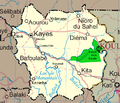
فائل:Un-mali Kayes Region.png

صفحے کے مندرجات دوسری زبانوں میں قابل قبول نہیں ہیں۔
آزاد دائرۃ المعارف، ویکیپیڈیا سے

Un-mali_Kayes_Region.png(692 × 594 پکسل، فائل کا حجم: 208 کلوبائٹ، MIME قسم: image/png)

یہ فائل ویکی ذخائر کی ہے اور دیگر منصوبوں کے زیر استعمال ہوسکتی ہے۔ فائل کے صفحہ تعارف پر موجود تعارف ذیل میں موجود ہے۔

خلاصہ

تفصیل Map of the Kayes Region of Mali. Additions include new northern road via Diema, several towns, downgrade of road (in fact unpaved) from Kayes to Kenieba. Solid pink lines are paved, dashed are unpaved. Addition of National park of Boucle du Baoule. Ref: Ross Velton. Mali. Bradt UK and Globe Pequot US (2005/2006) ISBN 9781841620770 Made with GIMP
تاریخ
ماخذ self-made, edit, crop, recolored, several additions to Image:Un-mali.png from http://www.un.org/Depts/Cartographic/english/htmain.htm
مصنف T L Miles
اجازت
(فائل کا دوبارہ استعمال)

Modified versions of UNCS maps may be used provided that the UN name and reference number does not appear on any modified version and a link to the original map is provided. Modified UN maps are to be considered in the public domain. This applies worldwide SEE:

Public domain This image is a map derived from a United Nations map.

Unless stated otherwise, UN maps are to be considered in the public domain. This applies worldwide.
Some UN maps have special copyrights, as indicated on the map itself.

UN maps are, in principle, open source material and you can use them in your work or for making your own map. UN requests however that you delete the UN name, logo and reference number upon any modification to the map. Content of your map will be your responsibility. You can state in your publication, if you wish, something like: based on UN map … (map name, map number, revision number and date). See: Geospatial Information Section. And: Geospatial, location data for a better world.

دوسرے نسخے Image:Un-mali.png

اجازہ کاری

Public domain میں اس تخلیقی کام کے حقوق کا مالک ہوں اور اسے دائرہ عام میں شائع کرتا ہوں جس کا اطلاق عالمی سطح پر ہوتا ہے۔
بعض ملکوں میں یہ قانونی طور پر شاید ممکن نہ ہو؛ اگر ایسا ہے تو:
میں ہر ایک کو کسی بھی مقصد کے لیے بغیر کسی شرط کے اس تصویر کے استعمال کا حق تفویض کرتا/کرتی ہوں، بجز اس صورت کے جس میں کوئی قانونی رکاوٹ موجود ہو۔

Captions

Add a one-line explanation of what this file represents

Items portrayed in this file

عکاسی

4 مارچ 2008

فائل کا تاریخچہ

کسی خاص وقت یا تاریخ میں یہ فائل کیسی نظر آتی تھی، اسے دیکھنے کے لیے اس وقت/تاریخ پر کلک کریں۔

تاریخ/وقتتھمب نیلابعادصارفتبصرہ
رائج الوقت18:42، 4 مارچ 2008ءمورخہ 18:42، 4 مارچ 2008ء کا تھمب نیل692 × 594 (208 کلوبائٹ)T L Miles{{Information |Description=Map of the Kayes Region of Mali. Additions include new northern road via Diema, several towns, downgrade of road (in fact unpaved) from Kayes to Kenieba. Solid pink lines are paved, dashed are unpaved. Addition of National pa

درج ذیل 2 صفحات اس فائل کو استعمال کر رہے ہیں:

فائل کا عالمی استعمال

مندرجہ ذیل ویکیوں میں یہ فائل زیر استعمال ہے: