
فائل:Worcestershire UK locator map 2010.svg

اس SVG فائل کی PNG نمائش کا حجم: 494 × 600 پکسلز دیگر تصمیمات: 198 × 240 پکسلز | 395 × 480 پکسلز | 633 × 768 پکسلز | 843 × 1,024 پکسلز | 1,687 × 2,048 پکسلز | 1,108 × 1,345 پکسلز۔
اصل فائل (ایس وی جی فائل، ابعاد 1,108 × 1,345 پکسل، فائل کا حجم: 302 کلوبائٹ)
خلاصہ
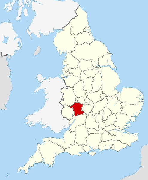
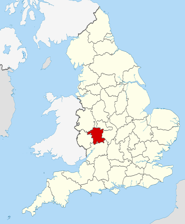
| تفصیل | Location of the ceremonial county of Worcestershire within England. |
| تاریخ | |
| ماخذ |
National Geospatial-Intelligence Agency
|
| مصنف | Nilfanion |
اجازہ کاری
میں اس کام کا کاپی رائٹ ہولڈر ہوں اور اسے مندرجہ ذیل اجازت ناموں کے تحت شائع کیا ہے:
اس ملف کا لائسنس Creative Commons Attribution-Share Alike 3.0 Unported کے تحط ہے۔
- آپ آزاد ہیں:
- شیئر کرنے – کام کو نقل، تقسیم یا منتقل کرنے کے لیے
- ریمکس کے لیے – کام منبطق کرنے کے لیے
- مندرجہ ذیل شرائط کے تحت:
- انتساب – آپ کو اس کام کا انتساب مصنف یا اجازت دہندہ کے بتائے گئے طریقہ کے مطابق دینا ہوگا (تاہم یہ انتساب اس طرح نہیں ہونا چاہیے کہ اسے دیکھ کر ایسا محسوس ہو کہ اصل مصنف یا اجازت دہندہ آپ کے یا آپ کے ذریعہ اس کام کے استعمال کرنے کے حامی ہیں)۔
- یکساں شراکت – اگر آپ اس کام میں کوئی تبدیلی یا ترمیم کرتے ہیں یا اس کام پر مبنی کچھ نیا بناتے ہیں تو اسے بھی آپ اسی یا اس جیسے کسی اجازت نامے کے تحت شائع کر سکتے ہیں۔

|
آپ کو آزاد سافٹ ویئر فاؤنڈیشن کی جانب سے شائع کردہ جی این یو آزاد مسوداتی اجازت نامہ کی شرائط استعمال کے تحت اس دستاویز کو نقل، تقسیم اور/ یا ترمیم کرنے کی اجازت دی جاتی ہے۔ اس اجازت نامہ کی ایک نقل 'جی این یو آزاد مسوداتی اجازت نامہ کے عنوان سے میسر ہے۔ |
آپ حسب منشا اجازت نامہ منتخب کر سکتے ہیں۔

|
This is one of the images forming part of the Valued image set: Locator maps of the Ceremonial counties of England on Wikimedia Commons. The image set has been assessed under the valued image set criteria and is considered the most valued set on Commons within the scope:
Locator maps of the Ceremonial counties of England
You can see its nomination at Commons:Valued image candidates/Locator maps of English ceremonial counties. |
فائل کا تاریخچہ
کسی خاص وقت یا تاریخ میں یہ فائل کیسی نظر آتی تھی، اسے دیکھنے کے لیے اس وقت/تاریخ پر کلک کریں۔
| تاریخ/وقت | تھمب نیل | ابعاد | صارف | تبصرہ | |
|---|---|---|---|---|---|
| رائج الوقت | 22:49، 23 نومبر 2010ء | | 1,108 × 1,345 (302 کلوبائٹ) | Nilfanion | == Summary == {{Information |Description=Location of the ceremonial county of Worcestershire within England. |Source=Ordnance Survey [https://www.ordnancesurvey.co.uk/opendatadownload/products.html OpenData]: *Co |
روابط
درج ذیل صفحہ اس فائل کو استعمال کر رہا ہے:
فائل کا عالمی استعمال
مندرجہ ذیل ویکیوں میں یہ فائل زیر استعمال ہے:
- af.wikipedia.org پر استعمال
- ast.wikipedia.org پر استعمال
- be-tarask.wikipedia.org پر استعمال
- be.wikipedia.org پر استعمال
- bg.wikipedia.org پر استعمال
- ca.wikipedia.org پر استعمال
- ceb.wikipedia.org پر استعمال
- cs.wikipedia.org پر استعمال
- dag.wikipedia.org پر استعمال
- en.wikipedia.org پر استعمال
- Worcestershire
- Stoke Heath, Worcestershire
- Lindridge
- Bordesley, Worcestershire
- Frankley
- Wadborough
- Pinvin
- Areley Kings
- Leigh, Worcestershire
- Wychbury Hill
- Romsley, Worcestershire
- Lickey End
- Hopwood, Worcestershire
- Ryall, Worcestershire
- Holt Heath, Worcestershire
- Lydiate Ash
- Heightington
- Rock, Worcestershire
- Mamble
- Ab Lench
- Abberton, Worcestershire
- Pirton, Worcestershire
- Pensham
- Norton, Worcestershire
- Whittington, Worcestershire
- Midlands Plateau
- Wyre Piddle
- Hill and Moor
- Martin Hussingtree
- Template:Worcestershire-geo-stub
- Aldington, Worcestershire
- Queenhill
- Stockton on Teme
- Ashton under Hill
- Bayton
- Besford
- Bickmarsh
- Birlingham
- Birtsmorton
- Bishampton
اس فائل کا مزید عالمی استعمال دیکھیے۔