
فائل:Kerch Strait Landsat.jpg

اس نمائش کا حجم: 800 × 600 پکسلز۔ دیگر تصمیمات: 320 × 240 پکسلز | 640 × 480 پکسلز | 1,024 × 768 پکسلز | 1,280 × 960 پکسلز | 1,600 × 1,200 پکسلز۔
اصل فائل (1,600 × 1,200 پکسل، فائل کا حجم: 294 کلوبائٹ، MIME قسم: image/jpeg)
خلاصہ
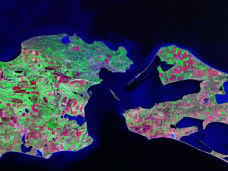
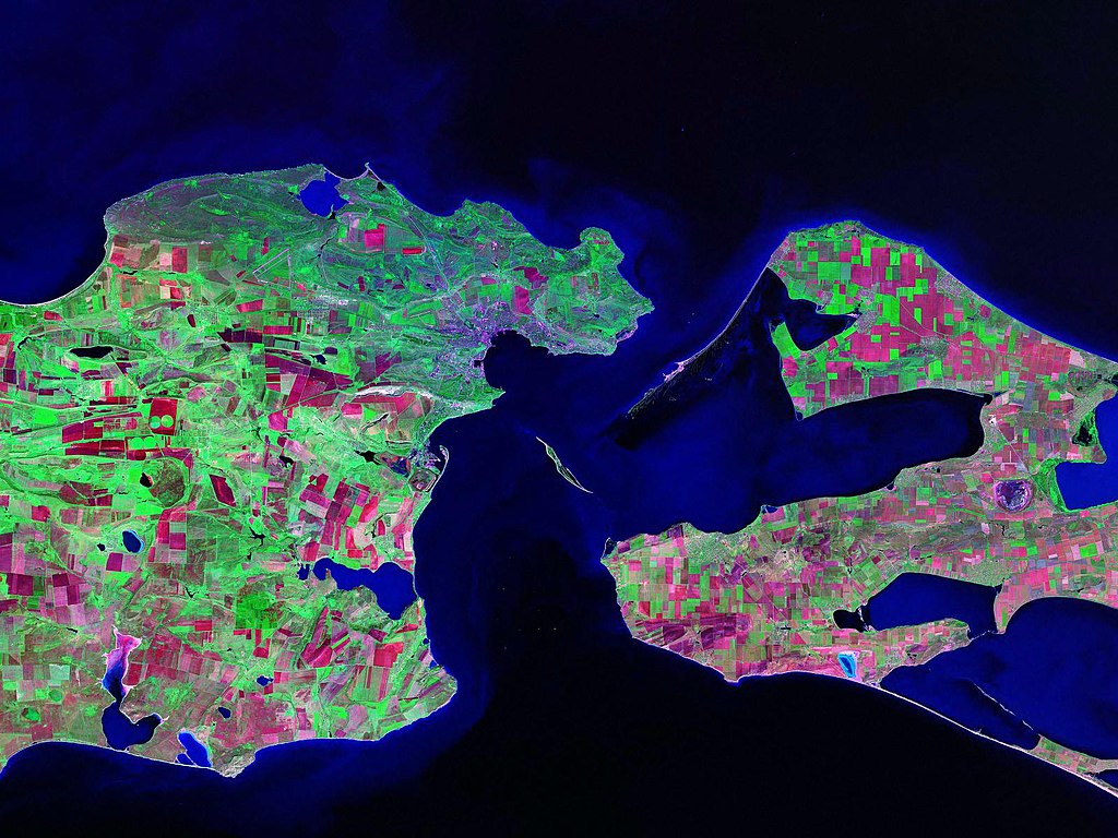
Landsat satellite (false color) photo of Kerch Strait between the Sea of Azov and the Black Sea.
Source: zulu.ssc.nasa.gov
| Camera location | | View this and other nearby images on: OpenStreetMap |
|---|
اجازہ کاری
| This file is in the public domain in the United States because it was solely created by NASA. NASA copyright policy states that "NASA material is not protected by copyright unless noted". (See Template:PD-USGov, NASA copyright policy page or JPL Image Use Policy.) | ||
 |
Warnings:
|
فائل کا تاریخچہ
کسی خاص وقت یا تاریخ میں یہ فائل کیسی نظر آتی تھی، اسے دیکھنے کے لیے اس وقت/تاریخ پر کلک کریں۔
| تاریخ/وقت | تھمب نیل | ابعاد | صارف | تبصرہ | |
|---|---|---|---|---|---|
| رائج الوقت | 13:52، 17 اکتوبر 2006ء | | 1,600 × 1,200 (294 کلوبائٹ) | Balcer~commonswiki | Landsat satellite (false color) photo of Kerch Strait between the Sea of Azov and the Black Sea. Source:zulu.ssc.nasa.gov Category:Black Sea Category:Satellite pictures of Russia Category:Satellite pictures of Ukraine |
روابط
درج ذیل صفحہ اس فائل کو استعمال کر رہا ہے:
فائل کا عالمی استعمال
مندرجہ ذیل ویکیوں میں یہ فائل زیر استعمال ہے:
- be.wikipedia.org پر استعمال
- ca.wikipedia.org پر استعمال
- ceb.wikipedia.org پر استعمال
- crh.wikipedia.org پر استعمال
- cs.wikipedia.org پر استعمال
- de.wikipedia.org پر استعمال
- el.wikipedia.org پر استعمال
- en.wikipedia.org پر استعمال
- eo.wikipedia.org پر استعمال
- es.wikipedia.org پر استعمال
- fa.wikipedia.org پر استعمال
- fi.wikipedia.org پر استعمال
- fr.wikipedia.org پر استعمال
- hr.wikipedia.org پر استعمال
- hy.wikipedia.org پر استعمال
- it.wikipedia.org پر استعمال
- ko.wikipedia.org پر استعمال
- nn.wikipedia.org پر استعمال
- no.wikipedia.org پر استعمال
- pl.wikipedia.org پر استعمال
- pnb.wikipedia.org پر استعمال
- pt.wikipedia.org پر استعمال
- ru.wikipedia.org پر استعمال
- sk.wikipedia.org پر استعمال
- sv.wikipedia.org پر استعمال
- tr.wikipedia.org پر استعمال
- ug.wikipedia.org پر استعمال
- uk.wikipedia.org پر استعمال
- Конфлікт щодо острова Тузла
- Керченська протока
- Користувач:Alex Blokha/Події в Вікіпедії/6 жовтня
- Користувач:Alex Blokha/Події в Вікіпедії/23 жовтня
- Користувач:Alex Blokha/Події в Вікіпедії/2 грудня
- Користувач:Alex Blokha/Події в Вікіпедії/7 січня
- Користувач:Alex Blokha/Події в Вікіпедії/19 лютого
- Державний кордон України
- Користувач:Alex Blokha/Дні згадані в Вікіпедії/Україна/6 жовтня
- Користувач:Alex Blokha/Дні згадані в Вікіпедії/Україна/22 жовтня
- Користувач:Alex Blokha/Дні згадані в Вікіпедії/Україна/2 грудня
- Користувач:Alex Blokha/Дні згадані в Вікіпедії/Україна/7 січня
اس فائل کا مزید عالمی استعمال دیکھیے۔