
فائل:New-Map-Francophone World.PNG

اس نمائش کا حجم: 800 × 441 پکسلز۔ دیگر تصمیمات: 320 × 176 پکسلز | 640 × 353 پکسلز | 1,024 × 564 پکسلز | 1,280 × 705 پکسلز | 2,664 × 1,468 پکسلز۔
اصل فائل (2,664 × 1,468 پکسل، فائل کا حجم: 93 کلوبائٹ، MIME قسم: image/png)
خلاصہ
| تفصیل |
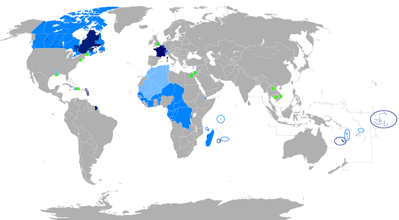
English: The French language and French creoles in the world
Regions where French or a French creole is the main language
Regions where it is an official language
Regions where it is a second language
Regions where it is a minority language
The following things have been changed from the old "Map-Francophone World.PNG":
To be modified :
Français : La langue française dans le monde
Langue maternelle
Langue officielle
Deuxième langue
Minorités francophones
Les choses suivantes ont été modifiées de l'ancien "Map-Frncophone World.PNG":
Proposition de modification : L'usage de la langue française est divers dans les pays d'Afrique subsaharienne. Par exemple, le français n'est pas la langue utilisée par défaut dans les rues sénégalaises. Tout au contraire, prétendre que le français n'est pas la langue maternelle des Gabonais reviendrait à dire que le français n'était rien de plus qu'une langue officielle dans la Bretagne des années cinquante. Ne connaissant pas la situation des autres pays, je laisse le soin à toute personne motivée de corriger cette erreur.
Català: La llengua francesa al món
Llengua materna
Llengua oficial
Segona Llengua
Minories francòfones |
| تاریخ | |
| ماخذ | ذاتی کام |
| مصنف | aaker |

|
File:New-Map-Francophone World.svg is a vector version of this file. It should be used in place of this PNG file when not inferior.
File:New-Map-Francophone World.PNG → File:New-Map-Francophone World.svg
For more information, see Help:SVG. |
 |
اجازہ کاری
| میں اس تخلیقی کام کے حقوق کا مالک ہوں اور اسے دائرہ عام میں شائع کرتا ہوں جس کا اطلاق عالمی سطح پر ہوتا ہے۔ بعض ملکوں میں یہ قانونی طور پر شاید ممکن نہ ہو؛ اگر ایسا ہے تو: میں ہر ایک کو کسی بھی مقصد کے لیے بغیر کسی شرط کے اس تصویر کے استعمال کا حق تفویض کرتا/کرتی ہوں، بجز اس صورت کے جس میں کوئی قانونی رکاوٹ موجود ہو۔ |
فائل کا تاریخچہ
کسی خاص وقت یا تاریخ میں یہ فائل کیسی نظر آتی تھی، اسے دیکھنے کے لیے اس وقت/تاریخ پر کلک کریں۔
| تاریخ/وقت | تھمب نیل | ابعاد | صارف | تبصرہ | |
|---|---|---|---|---|---|
| رائج الوقت | 00:15، 30 جولائی 2023ء | | 2,664 × 1,468 (93 کلوبائٹ) | Riad Salih | Western Sahara is an old Spanish colony, and French is not commonly used there. |
| 00:10، 30 جولائی 2023ء |  | 2,664 × 1,468 (93 کلوبائٹ) | Riad Salih | Since July 2023, French is no longer an official language in Mali, but a language of work. | |
| 06:49، 30 اپریل 2023ء |  | 2,664 × 1,468 (205 کلوبائٹ) | Moalli | Remove green square in middle of Mediterranean, no country located there | |
| 22:50، 15 مارچ 2023ء |  | 2,664 × 1,468 (105 کلوبائٹ) | Kwamikagami | update some per WP-en article, though this map not used much anymore | |
| 10:21، 9 اگست 2019ء |  | 2,664 × 1,468 (120 کلوبائٹ) | Benderban01 | Reverted to version as of 15:28, 17 July 2018 (UTC) | |
| 09:07، 6 اگست 2019ء |  | 2,664 × 1,468 (119 کلوبائٹ) | Benderban01 | Removed the small thing on ontario. | |
| 09:01، 6 اگست 2019ء |  | 2,664 × 1,468 (119 کلوبائٹ) | Benderban01 | Removed 8 provinces where french is not the official language, there 3 territorries which will spoke minority. | |
| 15:28، 17 جولائی 2018ء |  | 2,664 × 1,468 (120 کلوبائٹ) | Maphobbyist | Reverted to version as of 18:46, 4 January 2018 (UTC) | |
| 09:53، 27 جون 2018ء |  | 2,664 × 1,468 (100 کلوبائٹ) | Motiss | ||
| 09:50، 27 جون 2018ء |  | 2,664 × 1,468 (120 کلوبائٹ) | Motiss | Reverted to version as of 18:46, 4 January 2018 (UTC) |
روابط
اس فائل سے مربوط کوئی صفحہ موجود نہیں ہے۔
فائل کا عالمی استعمال
مندرجہ ذیل ویکیوں میں یہ فائل زیر استعمال ہے:
- de.wikipedia.org پر استعمال
- en.wikipedia.org پر استعمال
- Category:Wikipedians in Luxembourg
- Category:Wikipedians in Switzerland
- Category:WikiProject Luxembourg participants
- Category:WikiProject Switzerland participants
- Category:Swiss Wikipedians
- Talk:English language/Archive 18
- Talk:French language/Archive 3
- Category:Wikipedians interested in Luxembourg
- Category:Wikipedians interested in Switzerland
- Category:Luxembourg Wikipedians
- Template:Portal/doc/all
- Wikipedia:Reference desk/Archives/Humanities/2013 October 5
- User:Matt Fitzpatrick/portal images
- Wikipedia:Userboxes/Location/Luxembourg
- Wikipedia:Userboxes/Location/Switzerland
- Template:User Luxembourg/cat
- Template:User Switzerland/cat
- Template:User Luxembourg/boxes
- Template:User Switzerland/boxes
- es.wikipedia.org پر استعمال
- fi.wikipedia.org پر استعمال
- fr.wikipedia.org پر استعمال
- Discussion:Francophonie
- Discussion utilisateur:Le sotré
- Liste des pays ayant le français pour langue officielle
- Wikipédia:Le Bistro/24 février 2008
- Utilisateur:Brochon99/Bac à sable 5/Documentation
- Wikipédia:Le Bistro/18 décembre 2009
- Utilisateur:Kimdime/stats
- Utilisateur:Ygdrasil/http://Liste langue par nbr locuteur
- Utilisateur:Televido/Récolte
- Wikipédia:Le Bistro/25 juillet 2017
- Wikipédia:Le Bistro/30 juillet 2017
- fr.wikinews.org پر استعمال
- fr.wiktionary.org پر استعمال
- jv.wikipedia.org پر استعمال
- km.wikipedia.org پر استعمال
- nl.wikipedia.org پر استعمال
- so.wikipedia.org پر استعمال
- tum.wikipedia.org پر استعمال