
فائل:Suez Canal, Port Said - ISS 2.jpg

اس نمائش کا حجم: 800 × 585 پکسلز۔ دیگر تصمیمات: 320 × 234 پکسلز | 640 × 468 پکسلز | 1,024 × 749 پکسلز | 1,280 × 937 پکسلز | 2,744 × 2,008 پکسلز۔
اصل فائل (2,744 × 2,008 پکسل، فائل کا حجم: 2.54 MB، MIME قسم: image/jpeg)
خلاصہ
| تفصیل |
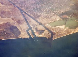
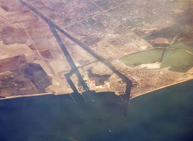
English: Port Said and the entrance to the Suez Canal. Photographed from the International Space Station.
|
| تاریخ | |
| ماخذ | http://eol.jsc.nasa.gov/SearchPhotos/photo.pl?mission=ISS013&roll=E&frame=44847 |
| مصنف | NASA astronaut |
| دوسرے نسخے |

اولین اپلوڈ کا نوشتہ
Gebruiker Ajoman, 10 aug 2006 20:55 1.000x750, description:Monding Suez kanaal. Afkomstig van NASA. June 30, 2006, source: suez)
اجازہ کاری
This file is in the public domain in the United States because it was created by the Image Science & Analysis Laboratory, of the NASA Johnson Space Center. NASA copyright policy states that "NASA material is not protected by copyright unless noted". (NASA media use guidelines or Conditions of Use of Astronaut Photographs).
Photo source: ISS013-E-44847.
|
فائل کا تاریخچہ
کسی خاص وقت یا تاریخ میں یہ فائل کیسی نظر آتی تھی، اسے دیکھنے کے لیے اس وقت/تاریخ پر کلک کریں۔
| تاریخ/وقت | تھمب نیل | ابعاد | صارف | تبصرہ | |
|---|---|---|---|---|---|
| رائج الوقت | 15:19، 13 جولائی 2016ء | | 2,744 × 2,008 (2.54 MB) | Ras67 | new rendered from NASA's raw image data in high quality |
| 11:39، 26 جولائی 2008ء |  | 1,000 × 750 (287 کلوبائٹ) | Dryke | {{Information |Description=Port Said and the entrance to the Suez Canal. Photographed from the International Space Station. |Source={{AstronautPhoto|mission=ISS013|roll=E|frame=44847}} |Date=30 June 2006 |Author=unnamed N |
روابط
درج ذیل صفحہ اس فائل کو استعمال کر رہا ہے:
فائل کا عالمی استعمال
مندرجہ ذیل ویکیوں میں یہ فائل زیر استعمال ہے:
- ar.wikipedia.org پر استعمال
- ast.wikipedia.org پر استعمال
- ceb.wikipedia.org پر استعمال
- de.wikipedia.org پر استعمال
- el.wikipedia.org پر استعمال
- en.wikipedia.org پر استعمال
- en.wikivoyage.org پر استعمال
- es.wikipedia.org پر استعمال
- eu.wikipedia.org پر استعمال
- fa.wikipedia.org پر استعمال
- fr.wikipedia.org پر استعمال
- he.wikipedia.org پر استعمال
- hu.wikipedia.org پر استعمال
- ja.wikipedia.org پر استعمال
- ja.wikivoyage.org پر استعمال
- ko.wikipedia.org پر استعمال
- mt.wikipedia.org پر استعمال
- ne.wikipedia.org پر استعمال
- nl.wikipedia.org پر استعمال
- nn.wikipedia.org پر استعمال
- pl.wikipedia.org پر استعمال
- pnb.wikipedia.org پر استعمال
- pt.wikipedia.org پر استعمال
- sh.wikipedia.org پر استعمال
- sr.wikipedia.org پر استعمال
- sv.wikipedia.org پر استعمال
- uk.wikivoyage.org پر استعمال