
فائل:DesertStormMap v2.svg

اس SVG فائل کی PNG نمائش کا حجم: 800 × 563 پکسلز دیگر تصمیمات: 320 × 225 پکسلز | 640 × 451 پکسلز | 1,024 × 721 پکسلز | 1,280 × 901 پکسلز | 2,560 × 1,802 پکسلز | 1,500 × 1,056 پکسلز۔
اصل فائل (ایس وی جی فائل، ابعاد 1,500 × 1,056 پکسل، فائل کا حجم: 3.13 MB)
|

خلاصہ
This W3C-unspecified vector image was created with Inkscape .
| عنوان |
Operation Desert Storm |
||||
| وضاحت |
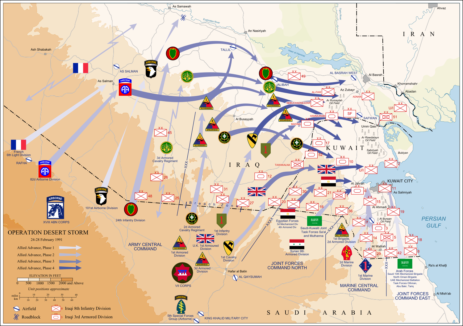
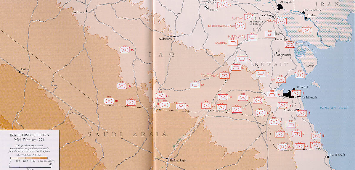
العربية: عملية عاصفة الصحراء، ضمن حرب الخليج الثانية، 24-28 شباط/ فبراير 1991.
English: Map of ground operations of Operation Desert Storm starting invasion February 24-28th 1991. Shows allied and Iraqi forces. Special arrows indicate the American 101st Airborne division moved by air and where the French 6st light division and American 3rd Armored Cavalry Regiment provided security.
Français : Carte montrant les opérations terrestres menées lors de l'opération Tempête du désert entre le 24 et le 28 février 1991 : les positions tenues par les armées irakienne et alliées, et les mouvements de cette dernière. Des flèches particulières indiquent les manœuvres héliportées pratiquées par la 101e division aéroportée, ainsi que les zones sécurisées par la 6e brigade légère blindée française et par le 3e régiment blindé de cavalerie américain. |
||||
| تاریخ | (UTC) | ||||
| ماخذ | self-vectored from Image:Operation Desert Storm.jpg from this site and this site. | ||||
| خالق |
US Army |
||||
| Geotemporal data | |||||
| تاریخی عکاسی | |||||
| Map location | Iraq/Kuwait border | ||||
| OpenStreetMap zoom level | 9 | ||||
| Bounding box |
|
||||
| Georeferencing | |||||
| Bibliographic data | |||||
| زبان | eng | ||||
| Archival data | |||||
| وسیلۂ تخلیق | Inkscape SVG | ||||
| دوسرے نسخے |
 |
||||

اجازہ کاری
This file is a work of a U.S. Army soldier or employee, taken or made as part of that person's official duties. As a work of the U.S. federal government, it is in the public domain in the United States.
|
 |
میں اس کام کا کاپی رائٹ ہولڈر ہوں اور اسے مندرجہ ذیل اجازت ناموں کے تحت شائع کیا ہے:

|
آپ کو آزاد سافٹ ویئر فاؤنڈیشن کی جانب سے شائع کردہ جی این یو آزاد مسوداتی اجازت نامہ کی شرائط استعمال کے تحت اس دستاویز کو نقل، تقسیم اور/ یا ترمیم کرنے کی اجازت دی جاتی ہے۔ اس اجازت نامہ کی ایک نقل 'جی این یو آزاد مسوداتی اجازت نامہ کے عنوان سے میسر ہے۔ |
This file is licensed under the Creative Commons Attribution-Share Alike 4.0 International, 3.0 Unported, 2.5 Generic, 2.0 Generic and 1.0 Generic license.
- آپ آزاد ہیں:
- شیئر کرنے – کام کو نقل، تقسیم یا منتقل کرنے کے لیے
- ریمکس کے لیے – کام منبطق کرنے کے لیے
- مندرجہ ذیل شرائط کے تحت:
- انتساب – آپ کو اس کام کا انتساب مصنف یا اجازت دہندہ کے بتائے گئے طریقہ کے مطابق دینا ہوگا (تاہم یہ انتساب اس طرح نہیں ہونا چاہیے کہ اسے دیکھ کر ایسا محسوس ہو کہ اصل مصنف یا اجازت دہندہ آپ کے یا آپ کے ذریعہ اس کام کے استعمال کرنے کے حامی ہیں)۔
- یکساں شراکت – اگر آپ اس کام میں کوئی تبدیلی یا ترمیم کرتے ہیں یا اس کام پر مبنی کچھ نیا بناتے ہیں تو اسے بھی آپ اسی یا اس جیسے کسی اجازت نامے کے تحت شائع کر سکتے ہیں۔
آپ حسب منشا اجازت نامہ منتخب کر سکتے ہیں۔
فائل کا تاریخچہ
کسی خاص وقت یا تاریخ میں یہ فائل کیسی نظر آتی تھی، اسے دیکھنے کے لیے اس وقت/تاریخ پر کلک کریں۔
| تاریخ/وقت | تھمب نیل | ابعاد | صارف | تبصرہ | |
|---|---|---|---|---|---|
| رائج الوقت | 13:14، 9 جون 2012ء | | 1,500 × 1,056 (3.13 MB) | Coolland | uploaded with x-external-editor |
| 04:31، 6 فروری 2008ء |  | 1,500 × 1,056 (3.13 MB) | Jeff Dahl | flags/label edits | |
| 21:00، 4 فروری 2008ء |  | 1,500 × 1,056 (2.89 MB) | Jeff Dahl | == Summary == {{Inkscape}} {{Information |Description=Map of ground operations of Operation Desert Storm from February 24-28th 1991. Shows allied and Iraqi forces. |Source=self-made, vectored from Image:Operation Desert Storm.jpg from [http://www.his |
روابط
درج ذیل صفحہ اس فائل کو استعمال کر رہا ہے:
فائل کا عالمی استعمال
مندرجہ ذیل ویکیوں میں یہ فائل زیر استعمال ہے:
- an.wikipedia.org پر استعمال
- ar.wikipedia.org پر استعمال
- bg.wikipedia.org پر استعمال
- br.wikipedia.org پر استعمال
- ca.wikipedia.org پر استعمال
- cs.wikipedia.org پر استعمال
- de.wikipedia.org پر استعمال
- el.wikipedia.org پر استعمال
- en.wikipedia.org پر استعمال
- French Foreign Legion
- Kuwait Armed Forces
- Armed Forces of Saudi Arabia
- 101st Airborne Division
- 82nd Airborne Division
- Gulf War
- 1st Cavalry Division (United States)
- 3rd Armored Division (United States)
- VII Corps (United States)
- 24th Infantry Division (United States)
- Norman Schwarzkopf Jr.
- 1st (United Kingdom) Division
- Air assault
- Battle of Khafji
- Royal Green Jackets (Rifles) Museum
- Iraqi invasion of Kuwait
- List of conflicts in Asia
- Opération Daguet
- Portal:Maps/Selected picture
- 1st Foreign Cavalry Regiment
- Wikipedia:WikiProject Iraq
- Wikipedia:Featured pictures thumbs/10
- Wikipedia:Featured picture candidates/February-2008
- Wikipedia:Featured picture candidates/Operation Desert Storm
- Wikipedia:Wikipedia Signpost/2008-02-18/Features and admins
- User talk:Jeff Dahl/Archive 3
- 82nd Sustainment Brigade
- Wikipedia:Featured pictures/Diagrams, drawings, and maps/Maps
- Wikipedia:WikiProject United States Government
- Wikipedia:Picture of the day/July 2008
- Template:POTD/2008-07-27
- User talk:Jeff Dahl/Archive 4
- Wikipedia:Wikipedia Signpost/2008-02-18/SPV
- Portal:Maps/Selected picture/38
- Wikipedia:WikiProject Military history/Showcase
- Wikipedia:WikiProject Military history/Showcase/FP
- 1st Brigade, 24th Infantry Division (United States)
اس فائل کا مزید عالمی استعمال دیکھیے۔