
فائل:Fula jihad states map general c1830.png
اس سے زیادہ ریزولیوشن دستیاب نہیں۔
Fula_jihad_states_map_general_c1830.png (694 × 408 پکسل، فائل کا حجم: 94 کلوبائٹ، MIME قسم: image/png)
خلاصہ
| تفصیل |
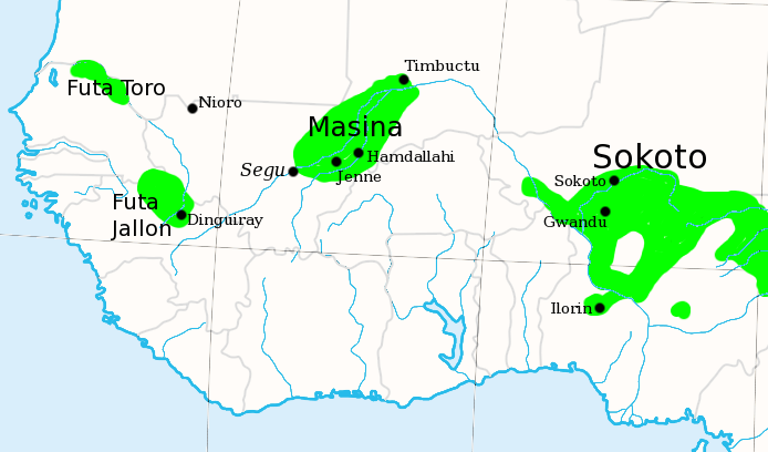
English: I made this, using the commons' en:Image:Africa_map_blank.svg as a template.
Shows the major Fula / Fulani /Peul Jihad states of West Africa, circa 1830, prior to the rise of Umar Tall. |
| تاریخ | 6 جولائی 2007 (original upload date) |
| ماخذ | Transfered from en.wikipedia |
| مصنف | Original uploader was T L Miles at en.wikipedia |
| اجازت (فائل کا دوبارہ استعمال) |
Released into the public domain (by the author). |

|
This historical map image could be re-created using vector graphics as an SVG file. This has several advantages; see Commons:Media for cleanup for more information. If an SVG form of this image is available, please upload it and afterwards replace this template with
{{vector version available|new image name}}.
It is recommended to name the SVG file “Fula jihad states map general c1830.svg”—then the template Vector version available (or Vva) does not need the new image name parameter. |
اجازہ کاری
| |
تخلیق کار T L Miles, at the انگریزی ویکیپیڈیا project نے اس کام کو دائرہ عام میں شائع کیا ہے جس کا اطلاق عالمی سطح پر ہوتا ہے۔ In case this is not legally possible: |
اولین اپلوڈ کا نوشتہ
فائل کی تفصیلات کا اصل صفحہ یہاں تھا۔ درج ذیل تمام صارفین en.wikipedia کے ہیں۔
- 2007-07-06 20:07 T L Miles 694×408×8 (96623 bytes) I made this, using the commons' [[Image:Africa_map_blank.svg]] as a template. Shows the major Fula / Fulani /Peul Jihad states of West Africa, circa 1830, prior to the rise of Umar Tall.
فائل کا تاریخچہ
کسی خاص وقت یا تاریخ میں یہ فائل کیسی نظر آتی تھی، اسے دیکھنے کے لیے اس وقت/تاریخ پر کلک کریں۔
| تاریخ/وقت | تھمب نیل | ابعاد | صارف | تبصرہ | |
|---|---|---|---|---|---|
| رائج الوقت | 15:50، 21 دسمبر 2007ء | | 694 × 408 (94 کلوبائٹ) | File Upload Bot (Magnus Manske) | {{BotMoveToCommons|en.wikipedia}} {{Information |Description={{en|I made this, using the commons' en:Image:Africa_map_blank.svg as a template. Shows the major Fula / Fulani /Peul Jihad states of West Africa, circa 1830, prior to the rise of Umar Ta |
روابط
درج ذیل 2 صفحات اس فائل کو استعمال کر رہے ہیں:
فائل کا عالمی استعمال
مندرجہ ذیل ویکیوں میں یہ فائل زیر استعمال ہے:
- af.wikipedia.org پر استعمال
- ar.wikipedia.org پر استعمال
- azb.wikipedia.org پر استعمال
- bm.wikipedia.org پر استعمال
- ca.wikipedia.org پر استعمال
- cs.wikipedia.org پر استعمال
- cy.wikipedia.org پر استعمال
- de.wikipedia.org پر استعمال
- de.wikiversity.org پر استعمال
- en.wikipedia.org پر استعمال
- eo.wikipedia.org پر استعمال
- es.wikipedia.org پر استعمال
- ff.wikipedia.org پر استعمال
- fi.wikipedia.org پر استعمال
- fr.wikipedia.org پر استعمال
- he.wikipedia.org پر استعمال
- id.wikipedia.org پر استعمال
اس فائل کا مزید عالمی استعمال دیکھیے۔