"لیسٹرشائر" کے نسخوں کے درمیان فرق
حذف شدہ مندرجات اضافہ شدہ مندرجات
نیا صفحہ: '''لیسٹرشائر''' (Leicestershire) (تلفظ؛ {{IPAc-en|audio=En-leicestershire.ogg|ˈ|l|ɛ|s|t|ə|ʃ|ə}} یا /ˈlestəʃɪə/) انگلستان کے علاقہ ... |
کوئی خلاصۂ ترمیم نہیں |
||
| سطر 1: | سطر 1: | ||
{{Infobox England county |
|||
| name = لیسٹرشائر<br />Leicestershire |
|||
| image = [[File:County flag of Leicestershire.svg|240px|Flag]] |
|||
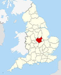
| map = [[File:Leicestershire UK locator map 2010.svg|200px|Leicestershire within England]] |
|||
| status = [[انگلستان کی رسمی کاؤنٹیاں|رسمی]] اور (چھوٹی) non-metropolitan]] county |
|||
| origin = <!-- (year of establishment for "new" counties) OPTIONAL --> |
|||
| region = [[مشرقی مڈلینڈز]] |
|||
| arearank = [[فہرست انگلستان کی رسمی کاؤنٹیاں|اٹھائیسواں]] |
|||
| area_km2 = 2156 |
|||
| adminarearank = [[فہرست انگلستان کی رسمی کاؤنٹیاں|بیسواں]] |
|||
| adminarea_km2 = 2083 |
|||
| adminhq = [[گلینفیلڈ، لیسٹرشائر|گلینفیلڈ]] |
|||
| iso = GB-LEC |
|||
| ons = 31 |
|||
| nutscode = <!-- NUTS x - (x = value entered, or leave blank for NUTS 3) - OPTIONAL --> |
|||
| nuts3 = UKF22 |
|||
| poprank = [[List of ceremonial counties of England by population|Ranked {{English cerem counties|RNK=Leicestershire}}]] |
|||
| popestdate = {{English statistics year}} |
|||
| pop = {{English cerem counties|POP=Leicestershire}} |
|||
| density_km2 = {{English cerem counties|DEN=Leicestershire}} |
|||
| adminpoprank = [[List of non-metropolitan counties of England by population|درجہ {{English admin counties|RNK=Leicestershire}}]] |
|||
| adminpop = {{English admin counties|POP=Leicestershire}} |
|||
| ethnicity = 85.0% سفید فام<br>11.9% جنوب ایشیائی<br>1.2% سیاہ فام برطانوی<br>1.5% مخلوط |
|||
| council =[[لیسٹرشائر کاؤنٹی کونسل]] |
|||
| exec = {{English county control|CTY=Leicestershire}} |
|||
| mps = * [[Stephen Dorrell]] [[Conservative Party (UK)|(C)]] |
|||
* [[Alan Duncan]] [[Conservative Party (UK)|(C)]] |
|||
* [[Edward Garnier]] [[Conservative Party (UK)|(C)]] |
|||
* [[Liz Kendall]] [[Labour Party (UK)|(L)]] |
|||
* [[Nicky Morgan (politician)|Nicky Morgan]] [[Conservative Party (UK)|(C)]] |
|||
* [[Andrew Robathan]] [[Conservative Party (UK)|(C)]] |
|||
* [[Jon Ashworth]] [[Labour Party (UK)|(L)]] |
|||
*[[Andrew Bridgen]] [[Conservative Party (UK)|(C)]] |
|||
* [[David Tredinnick (politician)|David Tredinnick]] [[Conservative Party (UK)|(C)]] |
|||
* [[Keith Vaz]] [[Labour Party (UK)|(L)]] |
|||
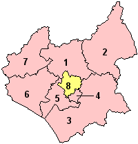
| subdivmap = [[File:Leicestershire Ceremonial Numbered.png|200 x 208px]] |
|||
| subdivs = #[[چارنووڈ (بورو)|چارنووڈ]] |
|||
#[[میلٹن (بورو)|میلٹن]] |
|||
#[[ہاربرا]] |
|||
#[[اواڈبی اور ویگسٹن]] |
|||
#[[بلابی (ضلع)|بلابی]] |
|||
#[[ہنکلے اور بوسورتھ]] |
|||
#[[شمالی مغربی لیسٹرشائر]] |
|||
#[[لیسٹر|لیسٹر شہر]] (وحدانی) |
|||
}} |
|||
'''لیسٹرشائر''' (Leicestershire) (تلفظ؛ {{IPAc-en|audio=En-leicestershire.ogg|ˈ|l|ɛ|s|t|ə|ʃ|ə}} یا /ˈlestəʃɪə/) [[انگلستان]] کے علاقہ [[زمرہ:مشرقی مڈلینڈز]] میں ایک [[انگلستان کی رسمی کاؤنٹیاں|کاؤنٹی]] ہے۔ |
'''لیسٹرشائر''' (Leicestershire) (تلفظ؛ {{IPAc-en|audio=En-leicestershire.ogg|ˈ|l|ɛ|s|t|ə|ʃ|ə}} یا /ˈlestəʃɪə/) [[انگلستان]] کے علاقہ [[زمرہ:مشرقی مڈلینڈز]] میں ایک [[انگلستان کی رسمی کاؤنٹیاں|کاؤنٹی]] ہے۔ |
||
نسخہ بمطابق 08:12، 28 جنوری 2015ء
| لیسٹرشائر Leicestershire | |
|---|---|
 | |

| |
| جغرافیہ | |
| حیثیت | رسمی اور (چھوٹی) non-metropolitan]] county |
| علاقہ | مشرقی مڈلینڈز |
| رقبہ - کل - انتظامی کونسل - انتظامی علاقہ |
اٹھائیسواں 2,156 کلومیٹر2 (2.321×10¹⁰ فٹ مربع) بیسواں 2,083 کلومیٹر2 (2.242×10¹⁰ فٹ مربع) |
| ایڈمن ہیڈ کوارٹر | گلینفیلڈ |
| آیزو 3166-2 | GB-LEC |
| او این ایس کوڈ | 31 |
| NUTS 3 | UKF22 |
| آبادیات | |
| آبادی - کل (mid-2018 تخمینہ.) - کثافت - انتظامی کونسل - انتظامی آبادی |
Ranked اکیسواں 980800 455/کلو میٹر2 (1,180/مربع میل) درجہ ستارہواں 651200 |
| نسلی پس منظر | 85.0% سفید فام 11.9% جنوب ایشیائی 1.2% سیاہ فام برطانوی 1.5% مخلوط |
| سیاست | |
| لیسٹرشائر کاؤنٹی کونسل | |
| ایگزیکٹو | |
| ارکان پارلیمنٹ | |
| اضلاع | |

| |
لیسٹرشائر (Leicestershire) (تلفظ؛ /ˈlɛstəʃə/ (![]() سنیے) یا /ˈlestəʃɪə/) انگلستان کے علاقہ میں ایک کاؤنٹی ہے۔
سنیے) یا /ˈlestəʃɪə/) انگلستان کے علاقہ میں ایک کاؤنٹی ہے۔
