
فائل:Adams bridge map.png
Adams_bridge_map.png (519 × 239 پکسل، فائل کا حجم: 25 کلوبائٹ، MIME قسم: image/png)
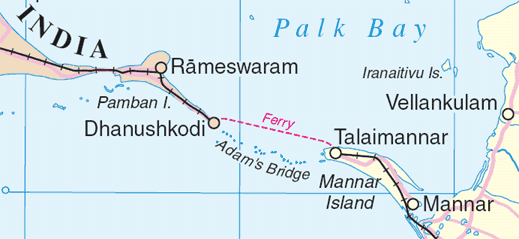
Map of en:Adam's Bridge, India/Sri Lanka
Extracted from www.un.org/Depts/Cartographic/map/profile/srilanka.pdf
| This image is a map derived from a United Nations map.
Unless stated otherwise, UN maps are to be considered in the public domain. This applies worldwide. UN maps are, in principle, open source material and you can use them in your work or for making your own map. UN requests however that you delete the UN name, logo and reference number upon any modification to the map. Content of your map will be your responsibility. You can state in your publication, if you wish, something like: based on UN map … (map name, map number, revision number and date). See: Geospatial Information Section. And: Geospatial, location data for a better world. |
 |
فائل کا تاریخچہ
کسی خاص وقت یا تاریخ میں یہ فائل کیسی نظر آتی تھی، اسے دیکھنے کے لیے اس وقت/تاریخ پر کلک کریں۔
| تاریخ/وقت | تھمب نیل | ابعاد | صارف | تبصرہ | |
|---|---|---|---|---|---|
| رائج الوقت | 01:55، 4 اگست 2006ء | | 519 × 239 (25 کلوبائٹ) | Gugganij | Map of Adam's Bridge, India/Sri Lanka Extracted from http://www.un.org/Depts/Cartographic/map/profile/srilanka.pdf {{UN map}} |
روابط
درج ذیل صفحہ اس فائل کو استعمال کر رہا ہے:
فائل کا عالمی استعمال
مندرجہ ذیل ویکیوں میں یہ فائل زیر استعمال ہے:
- ar.wikipedia.org پر استعمال
- az.wikipedia.org پر استعمال
- ba.wikipedia.org پر استعمال
- be.wikipedia.org پر استعمال
- bn.wikipedia.org پر استعمال
- cs.wikipedia.org پر استعمال
- de.wikipedia.org پر استعمال
- el.wikipedia.org پر استعمال
- en.wikipedia.org پر استعمال
- eo.wikipedia.org پر استعمال
- es.wikipedia.org پر استعمال
- et.wikipedia.org پر استعمال
- fi.wikipedia.org پر استعمال
- fr.wikipedia.org پر استعمال
- fy.wikipedia.org پر استعمال
- gl.wikipedia.org پر استعمال
- gu.wikipedia.org پر استعمال
- he.wikipedia.org پر استعمال
- hu.wikipedia.org پر استعمال
- id.wikipedia.org پر استعمال
- it.wikipedia.org پر استعمال
- ja.wikipedia.org پر استعمال
- kn.wikipedia.org پر استعمال
- ko.wikipedia.org پر استعمال
- la.wikipedia.org پر استعمال
- lt.wikipedia.org پر استعمال
- mai.wikipedia.org پر استعمال
- mk.wikipedia.org پر استعمال
- ml.wikipedia.org پر استعمال
- new.wikipedia.org پر استعمال
اس فائل کا مزید عالمی استعمال دیکھیے۔