
فائل:Historic American Buildings Survey W. N. Manning, Photographer, May 18, 1935 FRONT AND SIDE VIEW S. E. - Elmoreland, U.S. Highway 241, Glenville, Russell County, AL HABS ALA,57-GLENV,1-2.tif

اس TIF فائل کی JPG نمائش کا حجم: 800 × 574 پکسلز دیگر تصمیمات: 320 × 229 پکسلز | 640 × 459 پکسلز | 1,024 × 734 پکسلز | 1,280 × 918 پکسلز | 2,560 × 1,836 پکسلز | 5,000 × 3,585 پکسلز۔
اصل فائل (5,000 × 3,585 پکسل، فائل کا حجم: 17.1 MB، MIME قسم: image/tiff)
خلاصہ
| Historic American Buildings Survey W. N. Manning, Photographer, May 18, 1935 FRONT AND SIDE VIEW S. E. - Elmoreland, U.S. Highway 241, Glenville, Russell County, AL | ||||
|---|---|---|---|---|
| عنوان |
Historic American Buildings Survey W. N. Manning, Photographer, May 18, 1935 FRONT AND SIDE VIEW S. E. - Elmoreland, U.S. Highway 241, Glenville, Russell County, AL |
|||
| Depicted place | Alabama; Russell County; Glenville | |||
| ابعاد | 5 x 7 in. | |||
| مقام |
Library of Congress Prints and Photographs Division Washington, D.C. 20540 USA http://hdl.loc.gov/loc.pnp/pp.print |
|||
| اضافہ نمبر |
HABS ALA,57-GLENV,1-2 |
|||
| خط اعتبار |
|
|||
| ماخذ | https://www.loc.gov/pictures/item/al0711.photos.006540p | |||
| اجازت (فائل کا دوبارہ استعمال) |
|
|||

| Camera location | | View this and other nearby images on: OpenStreetMap |
|---|
فائل کا تاریخچہ
کسی خاص وقت یا تاریخ میں یہ فائل کیسی نظر آتی تھی، اسے دیکھنے کے لیے اس وقت/تاریخ پر کلک کریں۔
| تاریخ/وقت | تھمب نیل | ابعاد | صارف | تبصرہ | |
|---|---|---|---|---|---|
| رائج الوقت | 23:46، 29 جون 2014ء | 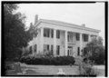 | 5,000 × 3,585 (17.1 MB) | Fæ | GWToolset: Creating mediafile for Fæ. HABS batch upload 29 June 2014 (101:150) |
روابط
درج ذیل صفحہ اس فائل کو استعمال کر رہا ہے:
فائل کا عالمی استعمال
مندرجہ ذیل ویکیوں میں یہ فائل زیر استعمال ہے:
- azb.wikipedia.org پر استعمال
- en.wikipedia.org پر استعمال
- fa.wikipedia.org پر استعمال
- zh.wikipedia.org پر استعمال