
فائل:OttomanEmpireIn1683 ar.png
اس نمائش کا حجم: 637 × 599 پکسلز۔ دیگر تصمیمات: 255 × 240 پکسلز | 510 × 480 پکسلز | 816 × 768 پکسلز | 1,088 × 1,024 پکسلز | 1,966 × 1,850 پکسلز۔
اصل فائل (1,966 × 1,850 پکسل، فائل کا حجم: 379 کلوبائٹ، MIME قسم: image/png)

|
This map image could be re-created using vector graphics as an SVG file. This has several advantages; see Commons:Media for cleanup for more information. If an SVG form of this image is available, please upload it and afterwards replace this template with
{{vector version available|new image name}}.
It is recommended to name the SVG file “OttomanEmpireIn1683 ar.svg”—then the template Vector version available (or Vva) does not need the new image name parameter. |
| تفصیل |
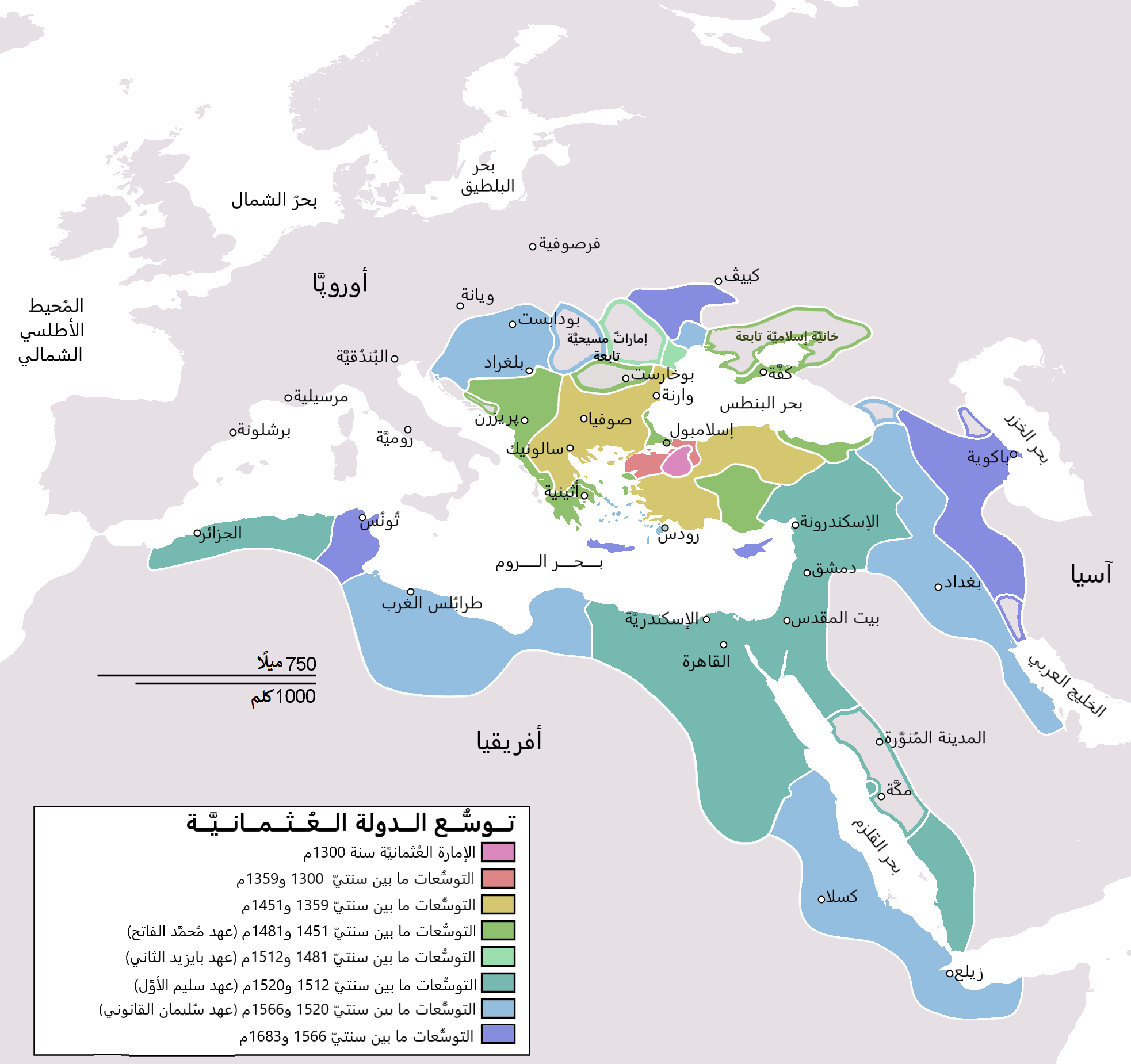
English: Map depicting the Ottoman Empire at its greatest extent, in 1683. Türkçe: Osmanlı İmparatorluğu en geniş sınırları (1683) |
| تاریخ | (UTC) |
| ماخذ | |
| مصنف |
|
| دوسرے نسخے |
[]
|


| This is a retouched picture, which means that it has been digitally altered from its original version. Modifications: translated to arabic. The original can be viewed here: OttomanEmpireIn1683.png:
|
میں اس تخلیقی کام کے حقوق کا مالک ہوں اور اسے مندرجہ ذیل اجازت نامے کے تحت شائع کرتا ہوں:
| میں اس تخلیقی کام کے حقوق کا مالک ہوں اور اسے دائرہ عام میں شائع کرتا ہوں جس کا اطلاق عالمی سطح پر ہوتا ہے۔ بعض ملکوں میں یہ قانونی طور پر شاید ممکن نہ ہو؛ اگر ایسا ہے تو: میں ہر ایک کو کسی بھی مقصد کے لیے بغیر کسی شرط کے اس تصویر کے استعمال کا حق تفویض کرتا/کرتی ہوں، بجز اس صورت کے جس میں کوئی قانونی رکاوٹ موجود ہو۔ |
اولین اپلوڈ کا نوشتہ
This image is a derivative work of the following images:
- File:OttomanEmpireIn1683.png licensed with PD-self
- 2010-12-10T23:11:12Z Lambiam 1966x1850 (347599 Bytes) Scale indicator more up to actual scale
- 2010-11-16T18:53:38Z Hamelin de Guettelet 1966x1850 (375469 Bytes) {{Information |Description= Rhodes et autres îles ne sont prises aux Hospitaliers que le 1 janvier 1523 |Source={{own}} |Date=16 novembre 2010 |Author=[[User:Hamelin de Guettelet|Hamelin de Guettelet]] |Permission= |other_ve
- 2010-04-01T10:40:16Z Nedim Ardoğa 1966x1850 (334406 Bytes) Reverted to version as of 07:37, 10 March 2010
- 2010-03-31T12:11:05Z Bahramm 2 637x599 (168664 Bytes) Reverted to version as of 14:12, 1 March 2010
- 2010-03-10T07:37:04Z Nedim Ardoğa 1966x1850 (334406 Bytes) Reverted to version as of 20:35, 21 February 2010
- 2010-03-01T14:12:01Z Bahramm 2 637x599 (168664 Bytes) Reverted to version as of 18:51, 24 January 2010
- 2010-02-21T20:35:06Z Nedim Ardoğa 1966x1850 (334406 Bytes) Reverted to version as of 15:12, 26 March 2007
- 2010-01-24T18:51:26Z Persia2099 637x599 (168664 Bytes) Minor Update
- 2007-03-26T15:12:25Z AtilimGunesBaydin 1966x1850 (334406 Bytes) Updated Ionian Islands.
- 2007-03-15T01:25:07Z Stevanb 1966x1850 (310597 Bytes) Corrected some error. Very important (historical) Ottoman "city" in Balkan area is Prizren - on the map marked as Kosovo. Kosovo is region, Prizren is town (Ottoman "city").
- 2007-02-25T16:28:59Z AtilimGunesBaydin 1966x1850 (334954 Bytes) Minor update.
- 2007-02-18T02:34:25Z AtilimGunesBaydin 1966x1850 (335164 Bytes) Update territories, some city locations and labels.
- 2007-02-14T23:50:38Z AtilimGunesBaydin 1940x1500 (313464 Bytes) Minor fixes, updated some borders and the color scheme.
- 2006-12-23T00:55:59Z AtilimGunesBaydin 1684x1348 (289614 Bytes) Added more labels.
- 2006-12-21T17:47:33Z AtilimGunesBaydin 1684x1347 (249515 Bytes) {{Information |Description=Map depicting the [[:en:Ottoman Empire|Ottoman Empire]] at its greatest extent, in 1683. |Source=Self drawn, based on information mainly compiled from [[:Image:Ottoman 1683.png]], [http://fs.hunting
Uploaded with derivativeFX
فائل کا تاریخچہ
کسی خاص وقت یا تاریخ میں یہ فائل کیسی نظر آتی تھی، اسے دیکھنے کے لیے اس وقت/تاریخ پر کلک کریں۔
| تاریخ/وقت | تھمب نیل | ابعاد | صارف | تبصرہ | |
|---|---|---|---|---|---|
| رائج الوقت | 19:06، 4 نومبر 2021ء | | 1,966 × 1,850 (379 کلوبائٹ) | باسم | Fixed Several mistakes - تصويب أخطاءٌ عدَّة |
| 19:54، 17 جولائی 2015ء |  | 1,966 × 1,850 (431 کلوبائٹ) | باسم | Better Version - نسخة أفضل | |
| 19:58، 1 جنوری 2011ء |  | 637 × 599 (105 کلوبائٹ) | باسم | {{Information |Description={{en|Map depicting the Ottoman Empire at its greatest extent, in 1683.}} {{tr|Osmanlı İmparatorluğu en geniş sınırları (1683)}} |Source=*[[:File:OttomanEmpireIn1683. |
روابط
درج ذیل صفحہ اس فائل کو استعمال کر رہا ہے:
فائل کا عالمی استعمال
مندرجہ ذیل ویکیوں میں یہ فائل زیر استعمال ہے:
- ar.wikipedia.org پر استعمال
- الدولة العثمانية
- تركيا
- سليمان القانوني
- أهل السنة والجماعة
- غامد
- تاريخ ليبيا
- أتراك
- ترك
- عثمانية جديدة
- قائمة سلاطين الدولة العثمانية
- مستخدم:منصورالواقدي/ملعب
- الأقليات التركية في الدولة العثمانية السابقة
- الدولة العثمانية في شبه الجزيرة العربية
- الحرب العثمانية الصفوية (1578–1590)
- الحرب العثمانية الصفوية (1603–1618)
- تاريخ الدولة العثمانية
- مرحلة ركود الدولة العثمانية
- قائمة أكبر الإمبراطوريات
- مستخدم:منصورالواقدي/مسودة
- التسلسل الزمني لتاريخ الشرق الأوسط
- شجرة العائلة العثمانية
- تاريخ منطقة البحر المتوسط
- إمبراطوريات الشرق الأوسط
- قائمة القوى العظمى الحديثة
- ولاية (هيمنة)
- مجتمعات تركية
- ar.wikiquote.org پر استعمال
- arz.wikipedia.org پر استعمال
- azb.wikipedia.org پر استعمال
- pnb.wikipedia.org پر استعمال