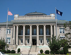
ماریون تاریخی ضلع (ماریون، ورجینیا)
Appearance
ماریون تاریخی ضلع (ماریون، ورجینیا) | |
{{{designated_other1_name}}}
| |
 | |
Smyth County Courthouse, August 2006 | |
| مقام | Roughly along Main, Cherry, Strother, Lee, North College and College Sts.; W. Cherry, E. Main, N. Main, Maple, N. Chestnut, Broad & N. Commerce Sts., ماریون، ورجینیا |
|---|---|
| متناسقات | 36°49′54″N 81°31′21″W / 36.83167°N 81.52250°W |
| رقبہ | 130 acre (53 ha) |
| معماری طرز | Beaux Arts, Queen Anne, et al. |
| گورننگ باڈی | Local |
| این آر ایچ پی حوالہ # | 00000888 |
| VLR # | 119-0012 |
| Significant dates | |
| این آر ایچ پی میں شامل | August 2, 2000, July 28, 2011 (Boundary Increase) |
| Designated VLR | June 14, 2000, December 18, 2008 |
ماریون تاریخی ضلع (ماریون، ورجینیا) (انگریزی: Marion Historic District (Marion, Virginia)) ریاستہائے متحدہ امریکا کا ایک historic district in the United States جو Roughly along Main, Cherry, Strother, Lee, North College and College Sts.; W. Cherry, E. Main, N. Main, Maple, N. Chestnut, Broad & N. Commerce Sts., Marion, Virginia میں واقع ہے۔[1]
مزید دیکھیے
[ترمیم]حوالہ جات
[ترمیم]- ↑ انگریزی ویکیپیڈیا کے مشارکین۔ "Marion Historic District (Marion, Virginia)"
|
|
