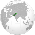
فائل:Pakistan (orthographic projection).svg

اس SVG فائل کی PNG نمائش کا حجم: 541 × 541 پکسلز دیگر تصمیمات: 240 × 240 پکسلز | 480 × 480 پکسلز | 768 × 768 پکسلز | 1,024 × 1,024 پکسلز | 2,048 × 2,048 پکسلز۔
اصل فائل (ایس وی جی فائل، ابعاد 541 × 541 پکسل، فائل کا حجم: 268 کلوبائٹ)
فائل کا تاریخچہ
کسی خاص وقت یا تاریخ میں یہ فائل کیسی نظر آتی تھی، اسے دیکھنے کے لیے اس وقت/تاریخ پر کلک کریں۔
| تاریخ/وقت | تھمب نیل | ابعاد | صارف | تبصرہ | |
|---|---|---|---|---|---|
| رائج الوقت | 06:32، 17 نومبر 2021ء |  | 541 × 541 (268 کلوبائٹ) | Gotitbro | Reverted to version as of 19:17, 10 November 2021 (UTC) gain consensus on enwiki or here, rather than edit warring; FWIW the discussion was on the svg editor's talk |
| 08:22، 12 نومبر 2021ء |  | 541 × 541 (280 کلوبائٹ) | Ytpks896 | Reverted to version as of 06:39, 24 October 2021 (UTC) All sources are provided for this, your self made discussion on your talk page doesn't matter, if you want to dispute it the start discussion on File talk page not yours | |
| 19:17، 10 نومبر 2021ء |  | 541 × 541 (268 کلوبائٹ) | Gotitbro | Reverted to version as of 05:04, 11 October 2021 (UTC) there is a linked discussion in the ES, no consensus at either enwiki or commons | |
| 06:39، 24 اکتوبر 2021ء |  | 541 × 541 (280 کلوبائٹ) | Ytpks896 | Reverted to version as of 10:39, 16 September 2021 (UTC) rvt this territory is disputed & claimed by the Pakistan, and also territory was included in official map of Pakistan all sources was provided about this, removing territory from map and providing summary not a 'new' claim; without any source or reference this is not a logic. | |
| 05:04، 11 اکتوبر 2021ء |  | 541 × 541 (268 کلوبائٹ) | Gotitbro | Reverted to version as of 16:08, 13 May 2020 (UTC) rvt contentious, not a 'new' claim; see User talk:Goran tek-en | |
| 10:39، 16 ستمبر 2021ء |  | 541 × 541 (280 کلوبائٹ) | Veverve | Reverted to version as of 12:10, 14 August 2021 (UTC) see summary for the source | |
| 08:10، 16 ستمبر 2021ء |  | 541 × 541 (168 کلوبائٹ) | Ksh.andronexus | Reverted to version as of 08:08, 16 September 2021 (UTC) | |
| 08:09، 16 ستمبر 2021ء |  | 541 × 541 (268 کلوبائٹ) | Ksh.andronexus | Reverted to version as of 08:06, 16 September 2021 (UTC) | |
| 08:08، 16 ستمبر 2021ء |  | 541 × 541 (168 کلوبائٹ) | Ksh.andronexus | Reverted to version as of 02:40, 9 January 2017 (UTC) | |
| 08:06، 16 ستمبر 2021ء |  | 541 × 541 (268 کلوبائٹ) | Ksh.andronexus | Is Pakistan on drugs to claim junagarh, please add a reference that is considerable, vandalising wiki leads to ban |
روابط
درج ذیل 20 صفحات اس فائل کو استعمال کر رہے ہیں:
- ایشیا کی خود مختار ریاستوں و تابع علاقہ جات کی فہرست
- پاکستان میں ایل جی بی ٹی حقوق
- پاکستان کا خاکہ
- صارف:کاشف عقیل/ریتخانہ
- سانچہ:باب:پاکستان/تعارف
- باب:اسلام آباد/تعارف
- باب:اسلام آباد، پاکستان
- باب:اسلام آباد، پاکستان/تعارف
- باب:بلوچستان
- باب:بلوچستان/تعارف
- باب:سوات
- باب:سوات/تعارف
- باب:سیالکوٹ
- باب:سیالکوٹ/تعارف
- باب:لاہور
- باب:لاہور/تعارف
- باب:پاکستان
- باب:پاکستان/تعارف
- باب:پاکستان میں ٹیکنالوجی
- باب:پاکستان میں ٹیکنالوجی/Intro
فائل کا عالمی استعمال
مندرجہ ذیل ویکیوں میں یہ فائل زیر استعمال ہے:
- ace.wikipedia.org پر استعمال
- ady.wikipedia.org پر استعمال
- af.wikipedia.org پر استعمال
- ami.wikipedia.org پر استعمال
- ar.wikipedia.org پر استعمال
- ar.wiktionary.org پر استعمال
- as.wikipedia.org پر استعمال
- av.wikipedia.org پر استعمال
- awa.wikipedia.org پر استعمال
- azb.wikipedia.org پر استعمال
- az.wiktionary.org پر استعمال
- ba.wikipedia.org پر استعمال
- bcl.wikipedia.org پر استعمال
- bh.wikipedia.org پر استعمال
- bn.wikipedia.org پر استعمال
- bo.wikipedia.org پر استعمال
- bpy.wikipedia.org پر استعمال
- bxr.wikipedia.org پر استعمال
- cdo.wikipedia.org پر استعمال
- ceb.wikipedia.org پر استعمال
- chr.wikipedia.org پر استعمال
- ch.wikipedia.org پر استعمال
- crh.wikipedia.org پر استعمال
- cs.wikipedia.org پر استعمال
- cu.wikipedia.org پر استعمال
- cv.wikipedia.org پر استعمال
- da.wikipedia.org پر استعمال
- dty.wikipedia.org پر استعمال
- el.wikipedia.org پر استعمال
- en.wikipedia.org پر استعمال
اس فائل کا مزید عالمی استعمال دیکھیے۔


