
فائل:The Border on Killeen School Road - geograph.org.uk - 446719.jpg
اس سے زیادہ ریزولیوشن دستیاب نہیں۔
The_Border_on_Killeen_School_Road_-_geograph.org.uk_-_446719.jpg (640 × 480 پکسل، فائل کا حجم: 71 کلوبائٹ، MIME قسم: image/jpeg)
خلاصہ
| تفصیل |
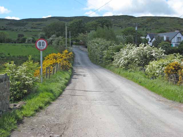
English: The Irish Border between Northern Ireland and Ireland on Killeen School Road in Killeen, County Armagh, in Northern Ireland. The only indication that one is crossing into the Republic of Ireland is the speed limit sign expressed in kilometres per hour. There are no indications when one is travelling in the opposite direction. The Cooley Mountains are in the background. |
| تاریخ | |
| ماخذ | From geograph.org.uk |
| مصنف | Oliver Dixon |
| لگاؤ (required by the license) | Oliver Dixon / The Border on Killeen School Road / |
| Camera location | | View this and other nearby images on: OpenStreetMap |
|---|
_heading:202.00&language=ur)
| Object location | | View this and other nearby images on: OpenStreetMap |
|---|
_heading:202.00&language=ur)
اجازہ کاری

|
This image was taken from the Geograph project collection. See this photograph's page on the Geograph website for the photographer's contact details. The copyright on this image is owned by Oliver Dixon and is licensed for reuse under the Creative Commons Attribution-ShareAlike 2.0 license.
|
This file is licensed under the Creative Commons Attribution-Share Alike 2.0 Generic license.
لگاؤ: Oliver Dixon
- آپ آزاد ہیں:
- شیئر کرنے – کام کو نقل، تقسیم یا منتقل کرنے کے لیے
- ریمکس کے لیے – کام منبطق کرنے کے لیے
- مندرجہ ذیل شرائط کے تحت:
- انتساب – آپ کو اس کام کا انتساب مصنف یا اجازت دہندہ کے بتائے گئے طریقہ کے مطابق دینا ہوگا (تاہم یہ انتساب اس طرح نہیں ہونا چاہیے کہ اسے دیکھ کر ایسا محسوس ہو کہ اصل مصنف یا اجازت دہندہ آپ کے یا آپ کے ذریعہ اس کام کے استعمال کرنے کے حامی ہیں)۔
- یکساں شراکت – اگر آپ اس کام میں کوئی تبدیلی یا ترمیم کرتے ہیں یا اس کام پر مبنی کچھ نیا بناتے ہیں تو اسے بھی آپ اسی یا اس جیسے کسی اجازت نامے کے تحت شائع کر سکتے ہیں۔
فائل کا تاریخچہ
کسی خاص وقت یا تاریخ میں یہ فائل کیسی نظر آتی تھی، اسے دیکھنے کے لیے اس وقت/تاریخ پر کلک کریں۔
| تاریخ/وقت | تھمب نیل | ابعاد | صارف | تبصرہ | |
|---|---|---|---|---|---|
| رائج الوقت | 12:45، 4 فروری 2011ء | | 640 × 480 (71 کلوبائٹ) | GeographBot | == {{int:filedesc}} == {{Information |description={{en|1=The Border on Killeen School Road The only indication that one is crossing into the Irish Republic is the speed limit sign expressed in Kilometres per hour. Cooley Mountains in the background.}} |da |
روابط
درج ذیل صفحہ اس فائل کو استعمال کر رہا ہے:
فائل کا عالمی استعمال
مندرجہ ذیل ویکیوں میں یہ فائل زیر استعمال ہے:
- ar.wikipedia.org پر استعمال
- ca.wikipedia.org پر استعمال
- de.wikipedia.org پر استعمال
- en.wikipedia.org پر استعمال
- en.wikivoyage.org پر استعمال
- fr.wikipedia.org پر استعمال
- id.wikipedia.org پر استعمال
- it.wikipedia.org پر استعمال
- ja.wikipedia.org پر استعمال
- ko.wikipedia.org پر استعمال
- ms.wikipedia.org پر استعمال
- no.wikipedia.org پر استعمال
- pnb.wikipedia.org پر استعمال
- pt.wikipedia.org پر استعمال
- ru.wikipedia.org پر استعمال
- sd.wikipedia.org پر استعمال
- uk.wikipedia.org پر استعمال
- www.wikidata.org پر استعمال