لائنس ہیڈ سے ٹیبل ماؤنٹین کا منظربادلوں سے گھرا کیپ ٹاؤنٹیبل ماؤنٹین سے وسیع منظر۔ بائیں سے دائیں:لائنس ہیڈ، سگنل پہاڑ، روبین جزیرہ، کیپ ٹاؤن، ٹیبل خلیج اور شیطانی چوٹی.جزیرہ نمائے کیپ اور ٹیبل ماؤنٹینGeology of Table Mountain in relation to the geology of the rest of the Cape Peninsula.سلور درختڈسا یونفلوراجنگلاتDassies (rock hyrax)کیپٹن کک کے جہاز سے ٹیبل ماؤنٹین کا منظرڈے ولئیرس رزروئرٹیبل ماؤنٹین ایریل کیبل کارWinter ascent of Table Mountain. Hikers set out on one of the many popular trailsMaclear's beacon.Winter ascent of Table Mountain. Hikers set out on one of the many popular trails


 سگنل پہاڑی سے ایک منظر
 پہاڑ کے اوپر کیبل کار اسٹیشن
 کیبل کار
 کیپ ٹاؤن, Signal Hill, Table Bay and Robben Island as seen from the upper cable station of the Table Mountain Cableway.
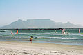 بلوبرگ اسٹرینڈ سے ٹیبل ماؤنٹین اور کیپ ٹاؤن کا منظر
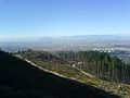 The concrete part of the Bridle Path—the most gradually-inclined route to the Back Table
 ٹیبل ماؤنٹین اور کیپ ٹاؤن ساحل
 پہاٹی کیبل اسٹیشن کا منظر
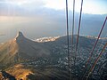 کیبل کار سے لئنس ہیڈ کا منظر
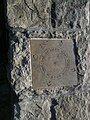 Time is a Gift, one of several plaques at the top of Table Mountain
 The Table Cloth draped over the north facing slopes
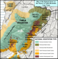 Map showing the conservation areas and forests of the Eastern Slopes. e.g. Newlands Forest, Cecilia Park, Kirstenbosch.
 View of Table Mountain from Blouberg beach.
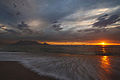 View of Table Mountain at sunset.
 As seen from the other side of Table Bay at sunset.


