کرسٹل سٹی، ورجینیا
| شہری علاقہ | |
 Downtown Crystal City in October 2005 | |
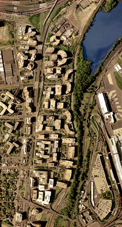
 Satellite image of the interlocking highrises of Crystal City. Jefferson Davis Highway (U.S. 1) can be seen running from north to south left of the image center. The main terminal of National Airport is in the bottom right corner of the image; a few lanes of I-395 are visible in the top left corner, immediately beyond which is پینٹا گون. At the bottom is State Route 233, the Airport Viaduct. Image from the United States Geological Survey, taken April 26, 2002. | |
| ملک | |
| ریاست | |
| کاؤنٹی | |
| آبادی (2000) | |
| • کل | 16,389 |
| منطقۂ وقت | مشرقی منطقۂ وقت (UTC-5) |
| • گرما (گرمائی وقت) | مشرقی منطقۂ وقت (UTC-4) |
| زپ کوڈs | 22202 |
| ٹیلی فون کوڈ | 703 |
کرسٹل سٹی، ورجینیا (انگریزی: Crystal City, Arlington, Virginia) ریاستہائے متحدہ امریکا کا ایک محلہ جو آرلنگٹن، ورجینیا میں واقع ہے۔[1]
تفصیلات[ترمیم]
کرسٹل سٹی، ورجینیا کی مجموعی آبادی 16,389 افراد پر مشتمل ہے۔
مزید دیکھیے[ترمیم]
حوالہ جات[ترمیم]
- ↑ انگریزی ویکیپیڈیا کے مشارکین۔ "Crystal City, Arlington, Virginia"
|
|
