
فائل:Danubemap.png
اس سے زیادہ ریزولیوشن دستیاب نہیں۔
Danubemap.png (747 × 480 پکسل، فائل کا حجم: 601 کلوبائٹ، MIME قسم: image/png)

|
This map image could be re-created using vector graphics as an SVG file. This has several advantages; see Commons:Media for cleanup for more information. If an SVG form of this image is available, please upload it and afterwards replace this template with
{{vector version available|new image name}}.
It is recommended to name the SVG file “Danubemap.svg”—then the template Vector version available (or Vva) does not need the new image name parameter. |
خلاصہ
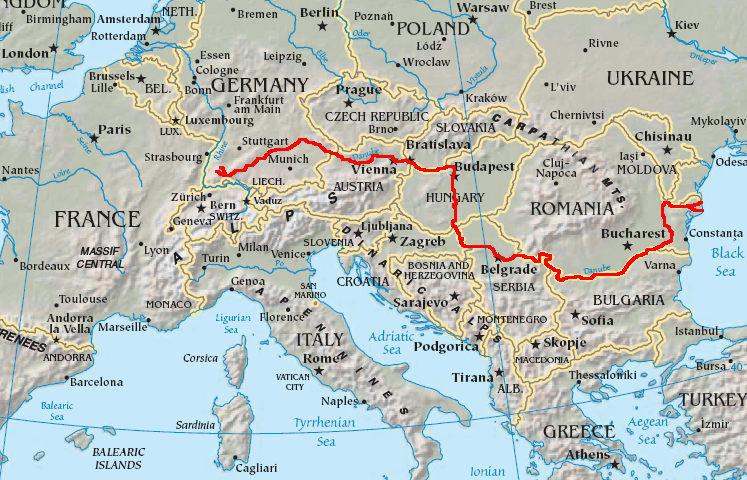
English: Map showing the flow of the Danube River. Uses the map of Europe from the CIA World Factbook.
اجازہ کاری
This image is in the public domain because it contains materials that originally came from the United States Central Intelligence Agency's World Factbook.
|
 |
فائل کا تاریخچہ
کسی خاص وقت یا تاریخ میں یہ فائل کیسی نظر آتی تھی، اسے دیکھنے کے لیے اس وقت/تاریخ پر کلک کریں۔
| تاریخ/وقت | تھمب نیل | ابعاد | صارف | تبصرہ | |
|---|---|---|---|---|---|
| رائج الوقت | 05:34، 12 فروری 2007ء | | 747 × 480 (601 کلوبائٹ) | Geologik | Map showing the flow of the Danube River. Uses the map of Europe from the CIA World Factbook. |
روابط
درج ذیل 7 صفحات اس فائل کو استعمال کر رہے ہیں:
فائل کا عالمی استعمال
مندرجہ ذیل ویکیوں میں یہ فائل زیر استعمال ہے:
- ang.wikipedia.org پر استعمال
- ast.wikipedia.org پر استعمال
- av.wikipedia.org پر استعمال
- azb.wikipedia.org پر استعمال
- ban.wikipedia.org پر استعمال
- be-tarask.wikipedia.org پر استعمال
- bg.wikipedia.org پر استعمال
اس فائل کا مزید عالمی استعمال دیکھیے۔