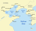
فائل:Bohaiseamap2.png

صفحے کے مندرجات دوسری زبانوں میں قابل قبول نہیں ہیں۔
آزاد دائرۃ المعارف، ویکیپیڈیا سے

Bohaiseamap2.png(569 × 487 پکسل، فائل کا حجم: 136 کلوبائٹ، MIME قسم: image/png)

یہ فائل ویکی ذخائر کی ہے اور دیگر منصوبوں کے زیر استعمال ہوسکتی ہے۔ فائل کے صفحہ تعارف پر موجود تعارف ذیل میں موجود ہے۔

Warning sign This file requires updating because: I suggest using the more normative 'Pyongyang' and 'Yellow River' or at least adding these forms in parentheses. In doing so, you could add a timestamp to the file.
Please notify the uploader with {{subst:update-note|1=File:Bohaiseamap2.png|2=I suggest using the more normative 'Pyongyang' and 'Yellow River' or at least adding these forms in parentheses.}} ~~~~

خلاصہ

تفصیل Map of the Bohai Sea and surrounding bays. For a more general map of the same area see Image:Bohai Sea map.png
تاریخ
ماخذ self-made, based on DCW data.
مصنف Kmusser
دوسرے نسخے

Derivative works of this file:

This map image could be re-created using vector graphics as an SVG file. This has several advantages; see Commons:Media for cleanup for more information. If an SVG form of this image is available, please upload it and afterwards replace this template with {{vector version available|new image name}}.


It is recommended to name the SVG file “Bohaiseamap2.svg”—then the template Vector version available (or Vva) does not need the new image name parameter.

اجازہ کاری

میں اس تخلیقی کام کے حقوق کا مالک ہوں اور اسے مندرجہ ذیل اجازت نامے کے تحت شائع کرتا ہوں:
w:en:Creative Commons
انتساب یکساں شراکت
This file is licensed under the Creative Commons Attribution-Share Alike 2.5 Generic license.
آپ آزاد ہیں:
  • شیئر کرنے – کام کو نقل، تقسیم یا منتقل کرنے کے لیے
  • ریمکس کے لیے – کام منبطق کرنے کے لیے
مندرجہ ذیل شرائط کے تحت:
  • انتساب – آپ کو اس کام کا انتساب مصنف یا اجازت دہندہ کے بتائے گئے طریقہ کے مطابق دینا ہوگا (تاہم یہ انتساب اس طرح نہیں ہونا چاہیے کہ اسے دیکھ کر ایسا محسوس ہو کہ اصل مصنف یا اجازت دہندہ آپ کے یا آپ کے ذریعہ اس کام کے استعمال کرنے کے حامی ہیں)۔
  • یکساں شراکت – اگر آپ اس کام میں کوئی تبدیلی یا ترمیم کرتے ہیں یا اس کام پر مبنی کچھ نیا بناتے ہیں تو اسے بھی آپ اسی یا اس جیسے کسی اجازت نامے کے تحت شائع کر سکتے ہیں۔

Captions

Add a one-line explanation of what this file represents
Map of the Bohai Sea and surrounding bays

Items portrayed in this file

عکاسی

27 جون 2007

MIME type انگریزی

image/png

checksum انگریزی

e776fb894d1db142a63c8f0d600c8d6c18de759c

طریق تعیین: SHA-1 انگریزی

data size انگریزی

139,100 لکمہ

487 عکصر

569 عکصر

فائل کا تاریخچہ

کسی خاص وقت یا تاریخ میں یہ فائل کیسی نظر آتی تھی، اسے دیکھنے کے لیے اس وقت/تاریخ پر کلک کریں۔

تاریخ/وقتتھمب نیلابعادصارفتبصرہ
رائج الوقت19:33، 7 جنوری 2021ءمورخہ 19:33، 7 جنوری 2021ء کا تھمب نیل569 × 487 (136 کلوبائٹ)Ras67black frame cropped and alpha channel removed
14:59، 27 جون 2007ءمورخہ 14:59، 27 جون 2007ء کا تھمب نیل583 × 500 (179 کلوبائٹ)Kmusseradded strait
14:50، 27 جون 2007ءمورخہ 14:50، 27 جون 2007ء کا تھمب نیل500 × 429 (141 کلوبائٹ)Kmusser{{Information |Description=Map of the Bohai Sea and surrounding bays. For a more general map of the same area see Image:Bohai Sea map.png |Source=self-made, based on DCW data. |Date=June 27, 2007

درج ذیل 4 صفحات اس فائل کو استعمال کر رہے ہیں:

فائل کا عالمی استعمال

مندرجہ ذیل ویکیوں میں یہ فائل زیر استعمال ہے:

اس فائل کا مزید عالمی استعمال دیکھیے۔

میٹا ڈیٹا