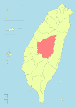
نانتوو کاؤنٹی
南投縣 | |
|---|---|
| تائیوان کی کاؤنٹیاں | |
 Top:Shuili Water Creek in Shuili Township, 2nd left:Mount Yu, 2nd right:Nantou County Museum of History in Nantou City, 3rd left:View of Sun Moon Lake, from Xuanzang Temple in Yuchi Township, 3rd right:Evergreen Glassland in Renci Township, Bottom left:Tou George Pond in Taiwan Educational University of Nature, Bottom right:Mount Hehuan | |
Nantou County پرچم | |
 | |
| ملک | جمہوریۂ چین |
| علاقہ | Central Taiwan |
| نشست | Nantou City |
| Largest city | Nantou City |
| بورو (انتظامیہ) | 1 cities, 12 (4 urban, 8 rural) townships |
| حکومت | |
| • County Magistrate | Lin Ming-chen (کومنتانگ) |
| رقبہ | |
| • کل | 4,106.436 کلومیٹر2 (1,585.504 میل مربع) |
| رقبہ درجہ | فہرست جمہوریۂ چین کی انتظامی تقسیمات |
| آبادی (Dec. 2014) | |
| • کل | 514,315 |
| • درجہ | فہرست جمہوریۂ چین کی انتظامی تقسیمات |
| منطقۂ وقت | CST (UTC+8) |
| ویب سائٹ | www.nantou.gov.tw |
| Symbols | |
| Flower | Plum blossom (Prunus mume) |
| Tree | Camphor Laurel (Cinnamomum camphora) |
نانتوو کاؤنٹی (انگریزی: Nantou County) جمہوریۂ چین کا ایک تائیوان کی کاؤنٹیاں جو صوبہ تائیوان میں واقع ہے۔[1]
تفصیلات[ترمیم]
نانتوو کاؤنٹی کا رقبہ 4,106.436 مربع کیلومیٹر ہے اور اس کی مجموعی آبادی 514,315 افراد پر مشتمل ہے۔
مزید دیکھیے[ترمیم]
حوالہ جات[ترمیم]
- ↑ انگریزی ویکیپیڈیا کے مشارکین۔ "Nantou County"
|
|

