اوستانکینسکی ضلع
| ضلع | |
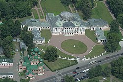
 Ostankino Palace, from the observation deck of the Ostankino Tower, Ostankinsky District | |
 Location of Ostankinsky District on the map of Moscow | |
| متناسقات: 55°49′50″N 37°37′16″E / 55.83056°N 37.62111°E | |
| ملک | روس |
| وفاقی اکائیاں | ماسکو |
| قیام | propertyreference |
| انتظامی مرکز | property |
| رقبہreference | |
| • کل | property کلومیٹر2 (خطاء تعبیری: غیر متوقع < مشتغل۔ میل مربع) |
| آبادی | |
| • تخمینہ (2018)reference | property |
| منطقۂ وقت | property[1] (UTC+property) |
| ویب سائٹ | http://ostankino.mos.ru/ |
اوستانکینسکی ضلع یا اوستانکینو ضلع (انگریزی: Ostankinsky District / Ostankino district) شمال-مشرقی انتظامی آکرگ کا ایک انتظامی ضلع (رایون) ہے اور ماسکو، روس کے 125 رایون میں سے ایک ہے۔ [2]
حواشی[ترمیم]
- ↑ "Об исчислении времени"۔ Официальный интернет-портал правовой информации (بزبان الروسية)۔ 3 June 2011۔ اخذ شدہ بتاریخ 19 جنوری 2019
- ↑ سانچہ:OKATO reference


