"ضلع شمالی وزیرستان" کے نسخوں کے درمیان فرق
حذف شدہ مندرجات اضافہ شدہ مندرجات
کوئی خلاصۂ ترمیم نہیں |
کوئی خلاصۂ ترمیم نہیں |
||
| سطر 11: | سطر 11: | ||
| image_caption = |
| image_caption = |
||
<!-- maps and coordinates ------> |
<!-- maps and coordinates ------> |
||
| image_map = KPK- |
| image_map = KPK-FATA2-NorthWazir.png |
||
| map_alt = |
| map_alt = |
||
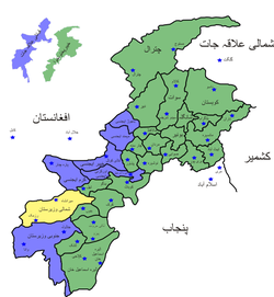
| map_caption = District map of FATA and Khyber-Pakhtunkhwa - Districts of FATA are shown shown in blue, Waziristan is located in the south. |
| map_caption = District map of FATA and Khyber-Pakhtunkhwa - Districts of FATA are shown shown in blue, Waziristan is located in the south. |
||
نسخہ بمطابق 09:48، 27 اگست 2012ء
شمالی وزیرستان | |
|---|---|
 District map of FATA and Khyber-Pakhtunkhwa - Districts of FATA are shown shown in blue, Waziristan is located in the south. | |
| Country | Pakistan |
| Established | 1910 |
| Headquarters | Miranshah |
| حکومت | |
| • Political agent | Muhammad Yahya Akhunzada |
| رقبہ | |
| • کل | 4,707 کلومیٹر2 (1,817 میل مربع) |
| آبادی (1998) | |
| • کل | 361,246 |
| • کثافت | 77/کلومیٹر2 (200/میل مربع) |
| منطقۂ وقت | PST (UTC+5) |
| Main language(s) | Pashto, English |
شمالی وزیرستان پاکستان کا ایک قبائلی علاقہ ہے جس کو شمالی وزیرستان ایجنسی بھی کہا جاتا ہے. اس کا صدرمقام میرانشاہ ہے .

