
"نیو انگلینڈ" کے نسخوں کے درمیان فرق
حذف شدہ مندرجات اضافہ شدہ مندرجات
2 مآخذ کو بحال کرکے 0 پر مردہ ربط کا ٹیگ لگایا گیا) #IABot (v2.0.7 |
1 مآخذ کو بحال کرکے 0 پر مردہ ربط کا ٹیگ لگایا گیا) #IABot (v2.0.7 |
||
| سطر 45: | سطر 45: | ||
| population_demonym = New Englander, [[Yankee]]<ref>{{cite web|url=http://www.thefreedictionary.com/Yankee|title=Yankee|work=The American Heritage Dictionary|year=2000|location=Boston|publisher=Houghton Mifflin Company|accessdate=March 28, 2011}}</ref> |
| population_demonym = New Englander, [[Yankee]]<ref>{{cite web|url=http://www.thefreedictionary.com/Yankee|title=Yankee|work=The American Heritage Dictionary|year=2000|location=Boston|publisher=Houghton Mifflin Company|accessdate=March 28, 2011}}</ref> |
||
| demographics_type1 = [[خام ملکی پیداوار]] |
| demographics_type1 = [[خام ملکی پیداوار]] |
||
| demographics1_footnotes =<ref name="2015Q2GDP">{{cite web|url=http://www.bea.gov/iTable/drilldown.cfm?reqid=70&stepnum=11&AreaTypeKeyGdp=5&GeoFipsGdp=XX&ClassKeyGdp=NAICS&ComponentKey=200&IndustryKey=1&YearGdp=2015Q2&YearGdpBegin=-1&YearGdpEnd=-1&UnitOfMeasureKeyGdp=Levels&RankKeyGdp=1&Drill=1&nRange=5|title=Gross domestic product (GDP) by state (millions of current dollars)|publisher=U.S. Department of Commerce. Bureau of Economic Analysis|accessdate=14 December 2015|archiveurl=https://web.archive.org/web/20181226112049/http://www.bea.gov/iTable/drilldown.cfm?reqid=70&stepnum=11&AreaTypeKeyGdp=5&GeoFipsGdp=XX&ClassKeyGdp=NAICS&ComponentKey=200&IndustryKey=1&YearGdp=2015Q2&YearGdpBegin=-1&YearGdpEnd=-1&UnitOfMeasureKeyGdp=Levels&RankKeyGdp=1&Drill=1&nRange=5|archivedate=2018-12-26|url-status= |
| demographics1_footnotes =<ref name="2015Q2GDP">{{cite web|url=http://www.bea.gov/iTable/drilldown.cfm?reqid=70&stepnum=11&AreaTypeKeyGdp=5&GeoFipsGdp=XX&ClassKeyGdp=NAICS&ComponentKey=200&IndustryKey=1&YearGdp=2015Q2&YearGdpBegin=-1&YearGdpEnd=-1&UnitOfMeasureKeyGdp=Levels&RankKeyGdp=1&Drill=1&nRange=5|title=Gross domestic product (GDP) by state (millions of current dollars)|publisher=U.S. Department of Commerce. Bureau of Economic Analysis|accessdate=14 December 2015|archiveurl=https://web.archive.org/web/20181226112049/http://www.bea.gov/iTable/drilldown.cfm?reqid=70&stepnum=11&AreaTypeKeyGdp=5&GeoFipsGdp=XX&ClassKeyGdp=NAICS&ComponentKey=200&IndustryKey=1&YearGdp=2015Q2&YearGdpBegin=-1&YearGdpEnd=-1&UnitOfMeasureKeyGdp=Levels&RankKeyGdp=1&Drill=1&nRange=5|archivedate=2018-12-26|url-status=dead}}</ref> |
||
| demographics1_title1 = کل |
| demographics1_title1 = کل |
||
| blank_name_sec1 = لہجے |
| blank_name_sec1 = لہجے |
||
نسخہ بمطابق 11:23، 20 ستمبر 2020ء
![[1]](/wiki/%D9%81%D8%A7%D8%A6%D9%84:Collage_of_New_England_related_images_2.png) | |
 پرچم | |
| نعرہ: "An appeal to heaven" | |
 Location of New England (red) in the United States | |
| اجزا | |
| سب سے بڑا میٹروپولیٹن علاقہ | |
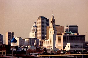
| سب سے بڑا شہر | بوسٹن, میساچوسٹس |
| رقبہ | |
| • کل | 186,458 کلومیٹر2 (71,991.8 میل مربع) |
| • زمینی | 162,362 کلومیٹر2 (62,688.4 میل مربع) |
| آبادی (2015 est.)[2] | |
| • کل | 14,727,584 |
| • کثافت | 90.7/کلومیٹر2 (234.9/میل مربع) |
| نام آبادی | New Englander, Yankee[3] |
| خام ملکی پیداوار[4] | |
| • کل | $953.9 بلین (2015) |
| لہجے | نیو انگلینڈ انگریزی، نیو انگلینڈ فرانسیسی |

نیو انگلینڈ (New England) چھ ریاستوں پر مشتمل ہے جس میں ایک جغرافیائی خطہ ہے جس میں شمال مشرقی ریاستہائے متحدہ کی کنیکٹیکٹ، میئن، میساچوسٹس، نیو ہیمپشائر، روڈ آئلینڈ اور ورمونٹ کی ریاستیں شامل ہیں۔
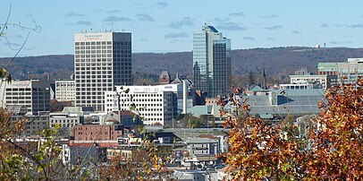
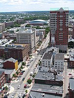
بڑے شہر
 بوسٹن، میساچوسٹس, میساچوسٹس: 655,884 (4,739,385)
- ووسٹر، میساچوسٹس: 183,016 (931,802)
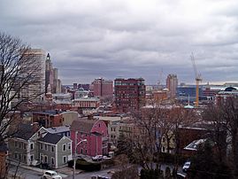
 پروویڈنس، روڈ آئلینڈ: 179,154 (1,609,533)
- سپرنگفیلڈ، میساچوسٹس: 153,991 (630,672)
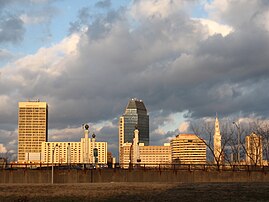
 برج پورٹ، کنیکٹیکٹ: 147,612 (945,816)
- نیو ہیون، کنیکٹیکٹ: 130,282 (861,238)
- سٹیمفورڈ، کنیکٹیکٹ: 128,278
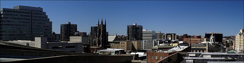
- ہارٹفورڈ، کنیکٹیکٹ: 124,705 (1,213,225)
 مانچسٹر، نیو ہیمپشائر: 110,448 (405,339)
- لوویل، میساچوسٹس: 109,945
- کیمبرج، میساچوسٹس: 109,694
- واٹربری، کنیکٹیکٹ: 109,307
- نیو بیڈفورڈ، میساچوسٹس: 94,845
- بروکٹن، میساچوسٹس: 94,779
- کوئنسی، میساچوسٹس: 93,397
انتخابات
| سال | کنیکٹیکٹ | میئن | میساچوسٹس | نیو ہیمپشائر | روڈ آئلینڈ | ورمونٹ | نیو انگلینڈ | ریاستہائے متحدہ امریکا |
|---|---|---|---|---|---|---|---|---|
| 2012 | 58.1% | 56.3% | 60.7% | 52.0% | 62.7% | 66.6% | 59.1% | 51.1% |
| 2008 | 60.6% | 57.7% | 61.8% | 54.1% | 62.9% | 67.5% | 60.6% | 52.9% |
| 2004 | 54.3% | 53.6% | 61.9% | 50.2% | 59.4% | 58.9% | 57.7% | 50.7% |
| 2000 | 55.9% | 49.1% | 59.8% | 48.1% | 61.0% | 50.6% | 56.1% | 48.4% |
| 1996 | 52.8% | 51.6% | 61.5% | 49.3% | 59.7% | 53.4% | 56.8% | 49.2% |
| 1992 | 42.2% | 38.8% | 47.5% | 38.9% | 47.0% | 46.1% | 44.4% | 43.0% |
| 1988 | 52.0% | 55.3% | 53.2% | 62.5% | 55.6% | 51.1% | 49.5% | 53.4% |
| 1984 | 60.7% | 60.8% | 51.2% | 68.7% | 51.7% | 57.9% | 56.2% | 58.8% |
| 1980 | 48.2% | 45.6% | 41.9% | 57.7% | 47.7% | 44.4% | 44.7% | 50.8% |
| 1976 | 52.1% | 48.9% | 56.1% | 54.7% | 55.4% | 54.3% | 51.7% | 50.1% |
| 1972 | 58.6% | 61.5% | 54.2% | 64.0% | 53.0% | 62.7% | 52.5% | 60.7% |
| 1968 | 49.5% | 55.3% | 63.0% | 52.1% | 64.0% | 52.8% | 56.1% | 43.4% |
| 1964 | 67.8% | 68.8% | 76.2% | 63.9% | 80.9% | 66.3% | 72.8% | 61.1% |
| 1960 | 53.7% | 57.0% | 60.2% | 53.4% | 63.6% | 58.6% | 56.0% | 49.7% |
| 1956 | 63.7% | 70.9% | 59.3% | 66.1% | 58.3% | 72.2% | 62.0% | 57.4% |
| 1952 | 55.7% | 66.0% | 54.2% | 60.9% | 50.9% | 71.5% | 56.1% | 55.2% |
| 1948 | 49.5% | 56.7% | 54.7% | 52.4% | 57.6% | 61.5% | 51.5% | 49.6% |
| 1944 | 52.3% | 52.4% | 52.8% | 52.1% | 58.6% | 57.1% | 52.4% | 53.4% |
| 1940 | 53.4% | 51.1% | 53.1% | 53.2% | 56.7% | 54.8% | 52.8% | 54.7% |
| 1936 | 55.3% | 55.5% | 51.2% | 49.7% | 53.1% | 56.4% | 50.9% | 60.8% |
| 1932 | 48.5% | 55.8% | 50.6% | 50.4% | 55.1% | 57.7% | 49.1% | 57.4% |
| 1928 | 53.6% | 68.6% | 50.2% | 58.7% | 50.2% | 66.9% | 53.2% | 58.2% |
| 1924 | 61.5% | 72.0% | 62.3% | 59.8% | 59.6% | 78.2% | 63.3% | 54.0% |
| 1920 | 62.7% | 68.9% | 68.5% | 59.8% | 64.0% | 75.8% | 66.7% | 60.3% |
| 1916 | 49.8% | 51.0% | 50.5% | 49.1% | 51.1% | 62.4% | 51.1% | 49.2% |
| 1912 | 39.2% | 39.4% | 35.5% | 39.5% | 39.0% | 37.1% | 36.6% | 41.8% |
| 1908 | 59.4% | 63.0% | 58.2% | 59.3% | 60.8% | 75.1% | 60.2% | 51.6% |
| 1904 | 58.1% | 67.4% | 57.9% | 60.1% | 60.6% | 78.0% | 60.4% | 56.4% |
| 1900 | 56.9% | 61.9% | 57.6% | 59.3% | 59.7% | 75.7% | 59.4% | 51.6% |
- نیو انگلینڈ کے بڑے شہر
-

-
-
-
-

-
-
-
-
 10. لوویل، میساچوسٹس
 -

-

-

-
-


بیرونی روابط
- سیاسی
- تاریخی
- Historic New England
- Minuteman National Park Homepage - American Revolution battle site
- نقشے
- Historic USGS Maps of New England & NY
- Map of New England. From the 1871 Atlas of Massachusetts by Walling and Gray.
- ثقافت
حوالہ جات
- ↑ Clockwise from top: skyline of بوسٹن, میساچوسٹس, Massachusetts's financial district at night; a building of ییل یونیورسٹی in نیو ہیون، کنیکٹیکٹ, کنیکٹیکٹ; a view from Nubble Light on Cape Neddick, میئن; view from ماؤنٹ مینسفیلڈ, ورمونٹ; and a fisherman on Cape Cod, میساچوسٹس.
- ↑ "Resident Population in the New England Census Division"۔ US Census Bureau۔ 26 دسمبر 2018 میں اصل سے آرکائیو شدہ۔ اخذ شدہ بتاریخ May 29, 2014
- ↑ "Yankee"۔ The American Heritage Dictionary۔ Boston: Houghton Mifflin Company۔ 2000۔ اخذ شدہ بتاریخ March 28, 2011
- ↑ "Gross domestic product (GDP) by state (millions of current dollars)"۔ U.S. Department of Commerce. Bureau of Economic Analysis۔ 26 دسمبر 2018 میں اصل سے آرکائیو شدہ۔ اخذ شدہ بتاریخ 14 دسمبر 2015

|
| |||
| بحر اوقیانوس | ||||
| بحیرہ سارگاسو | Long Island Sound • Block Island Sound |
44°12′20.00″N 70°18′23.13″W / 44.2055556°N 70.3064250°W
| موضوعات | |||||||
|---|---|---|---|---|---|---|---|
| ریاستیں | |||||||
| بڑے شہر | |||||||
| دار الحکومت | |||||||
| نقل و حمل |
| ||||||
.svg)